https://doi.org/10.26516/2541-9641.2025.3.7
EDN: ZZPYHC
The Tunka Valley and South Baikal Basin of the Baikal Rift System: introduction into rifting processes in the continental lithosphere *
S.V. Rasskazov1,2, I.S. Chuvashova1, S.V. Snopkov2,3
1Institute of the Earth's Crust SB RAS, Irkutsk, Russia
2Irkutsk State University, Irkutsk, Russia
3Irkutsk National Research Technical University, Irkutsk, Russia
Abstract. Brief overview of pre-Cenozoic basement, tectonic features, stratigraphic sequence of sedimentary and volcanic rocks of basins, mineral waters, dangerous geological processes, the tectonic development, deep structure of the crust and the underlying mantle is given for the Tunka Valley and South Baikal Basin. Concepts and terms are presented in a form accessible to a traveler who has come into contact with rifting processes in the continental lithosphere for the first time.
Keywords: Baikal, continental rifting, volcanism, groundwater, earthquake, mudflow, suture zone, pseudotachylite
Initial terms and definitions of continental rift zones and rift systems
The term "rift" was proposed in 1896 by the English geologist J. Gregory to denote a fault that formed due to gravitational forces. J. Gregory proposed to call the negative structure formed between two faults “rift basin” or “rift valley”.
Rifting processes of continents were intensively studied in the 1960s–1990s. In an introductory talk of the symposium “Problems of rifting”, held in Irkutsk in 1975, A.L. Yanshin, while discussing the problem of rift terminology, described rifts as “negative structures of the earth’s crust associated not simply with subsidence under the influence of gravity, as J. Gregory wrote, but with large horizontal extensions of the sialic layer that are accompanied by the formation of faults extending into the Earth’s mantle and displaying basic magmatism” (Yanshin, 1975, p. 5). In this definition, a rift was presented after J. Gregory as a crustal structure that influences the underlying mantle.
In the monograph by E.E. Milanovsky, published in the next year after the symposium, a detailed concept of a rift zone was suggested. "Rift zones are very long (many hundreds and thousands of kilometers long) planetary-scale strip-like tectonic zones, common within continents and oceans, in which there is an upwelling of deep (mantle) material, accompanied by its lateral spreading that leads to more or less significant transverse stretching in the upper layers of the earth's crust. The most important structural expression of the stretching process on the Earth's surface is usually the formation of a deep and relatively narrow (from several kilometers to several tens of kilometers), often stepped grabens (symmetrical or asymmetrical), limited by normal faults of great depth (the rift itself or "rift valley"), or several (sometimes a whole series) of such grabens... Rift zones, with rare exceptions, are characterized by an increased heat flow, the value of which generally increases as they approach their axis, often reaching 2–3, and sometimes even 4–5 heat flow units. The development of most rift zones is accompanied by displaying of hydrothermal activity and magmatism, and in particular, volcanic eruptions fed from subcrustal, and in some continental rift zones, perhaps also from intracrustal magmatic centers” (Milanovsky, 1976; p. 10). As we can see, this definition refers both to the lithospheric part of the mantle and to the crustal effects of the stretching process. The mechanism of stretching is indicated – the rise of deep (mantle) material, accompanied by its lateral spreading.
In the next monograph by N.A. Logatchev, the concept of “rift zone” was based, first of all, on the structural-geomorphological meaning of “a large strip-like uplift of the earth's surface, accompanied by one or several parallel grabens” (Logatchev, 1977; p. 8). The presence of grabens emphasized the structural effect of crustal stretching. In this definition, volcanism was not considered an essential feature of a rift zone, although the idea of dividing rift zones into dome-volcanic and weakly volcanic was advocated.
In studies of continental rifting, there was experience in identifying the Kenyan, Ethiopian, and Western rift branches (rift zones) within the East African region. Using these structures as an example, the definition of the concept of a “rift system” was introduced as a set of “a number of closely interconnected rift zones of similar or different types that are approximately the same age in space.” It was emphasized that “this term can be applied to any combination of rift zones, regardless of their size, complexity and pattern, but is mainly used in relation to those combinations that are characterized by the presence of differently oriented rift zones, a tree-like pattern or the presence of several semi-isolated branches, a general contour that is not striped but close to isometric” (Milanovsky, 1976; p. 11). As we can see, the concept of a “rift system” assumes two or more of its constituent structural elements (rift zones) as an essential feature.
In the evolution of ideas about rifting in the continental lithosphere, an important role was played by works on volcanism. In geodynamics as a science that aroused in the 1970s, a crucial place, along with the tectonic concept of lithospheric plates, was devoted to the concept of lithospheric and sub-lithospheric melting anomalies that was a result of a long discussion on the origin of intraplate magmatism. In the south of Siberia, rift basins and rift-related volcanism in Central Mongolia, Eastern Sayan, and Western Transbaikal extended far beyond the structural-geomorphological boundaries of the Baikal Rift Zone, therefore, in a broader sense, in such an expanded context, the rift structures of Southern Siberia were considered within the framework of the Baikal Rift System (Rasskazov, 1993).
A comprehensive understanding of continental rifts was provided in the thematic monograph published in the mid-1990s. “Rifts are now generally accepted to be extensional features, although they may be associated with earlier, contemporaneous, or later compression. Morphologically, they are well defined as elongate depressions bounded by normal faults. However, the common association of rifts with volcanism, high heat flow, anomalous crust and upper mantle structure, and seismicity provides compelling evidence that rifts are not confined to upper crustal levels, but that they are linked to dynamic processes in the lithosphere and asthenosphere” (Olsen, Morgan, 1995; p. 3). This definition shows progress in understanding different roles of the crust, lithosphere, and asthenosphere in rifting development.
Historical remarks on the discovery of the Baikal Rift Zone
The history of geological studies of the Tunka Valley spans several centuries. After numerous episodic visits by famous and lesser-known travelers, a major breakthrough in understanding the structure of the Tunka Basin and the Elovka Spur occurred in 1952, when during the summer field season N.A. Florensov organized geological mapping of the area at a scale of 1:100,000. N. Logatchev, a 1952 graduate from the Geological Faculty of Irkutsk State University, was involved in this work. It was he, who subsequently developed and substantiated a stratigraphic scheme for sedimentary deposits in basins of the Baikal rift zone and provided a basic summary of data on highlands of the Baikal and Transbaikal regions (Logatchev, 1958, 1974). The advancement of knowledge about the geology of the area was greatly facilitated by drilling of deep wells in the 1950s that revealed more than 2000 m of sedimentary-volcanogenic filling of the Tunka Basin. Results of the initial systematic study of the Tunka Valley were generally confirmed through special work on Cenozoic basalts that was accompanied by K–Ar dating of volcanic units (Rasskazov, 1993).
A clear understanding of the Tunka Valley structure was achieved by the mid-1970s mainly due to studies by N.A. Florensov and N.A. Logatchev, who brought it to the international level as a classic object of Cenozoic continental rifting. In 1975, the international symposium on rifting problems with a geological excursion to the Tunka Valley was organized in Irkutsk (Geological excursions…, 1975). Subsequently, the Tunka Valley was visited by participants of other international and Russian conferences (Logatchev et al., 1981, 1984; Logatchev, 1987; Rasskazov et al., 2010; Levitsky et al., 2021).
Educational field trainings of students of the ISU geological faculty have been held in the Tunka Valley for many years. In 2011, the Vyshka resort, organized on deep wells that yielded thermal waters, hosted the International Scientific and Practical Conference "Tunka National Park - 20 years", at which materials were presented on the geology of the Tunka Valley as a diverse excursion area for both knowlegeble geologists and young people who have not yet entered the geological profession – students and schoolchildren (Rasskazov et al., 2011).
The aim of this paper is to present a concise geological overview of the Tunka Valley and adjacent South Baikal Basin, accessible to visitors who have come into contact with rifting processes for the first time. For initial acquaintance with rifting processes in this review, highlighted are pre-Cenozoic basement and rift structures, results of studies of sedimentary and volcanic rocks, mineral waters, and also dangerous geological phenomena – earthquakes and mudflows.
The Baikal Rift System – a classic extensional continental structure of the Earth
Under the conditions of gravity dominance, the upper shell of the Earth – the Earth's crust – is affected by all-round compression. However, not only compression structures, but also extension ones are widespread on the Earth's surface. Extension is concentrated in both continental rift systems and oceanic spreading belts (Fig. 1).
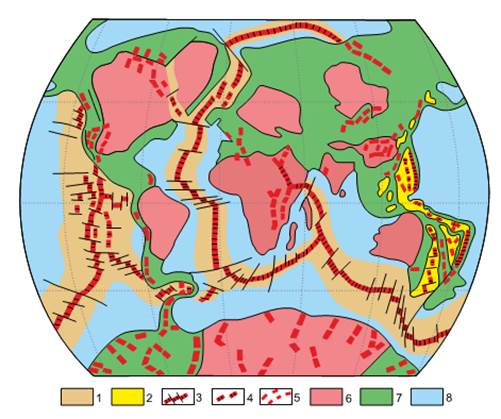
Fig. 1. Distribution of Cenozoic continental rift zones, systems, and oceanic spreading belts of the Earth (Milanovsky, 1999). 1 – intraoceanic spreading belts; 2 – West Pacific marginal oceanic spreading belt; 3 – active axial zones of spreading belts and transform faults intersecting them; 4 – extinct axial zones of spreading belts; 5 – continental rift zones and systems; 6 – stable cores of continents – old platforms; 7 – mobile belts within continents and their margins; 8 – areas of the ocean floor outside the Cenozoic spreading belts mainly with Mesozoic oceanic-type crust.
Рис. 1. Распространение кайнозойских континентальных рифтовых зон, систем и океанических спрединговых поясов Земли (Милановский, 1999). 1 – внутриокеанические спрединговые пояса; 2 – Западно-Тихоокеанский окраинно-океанический спрединговый пояс; 3 – активные осевые зоны спрединговых поясов и пересекающие их трансформные разломы; 4 – отмершие осевые зоны спрединговых поясов; 5 – континентальные рифтовые зоны и системы; 6 – стабильные ядра континентов – древние платформы; 7 – подвижные пояса в пределах континентов и их окраин; 8 – области дна океанов вне кайнозойских спрединговых поясов преимущественно с мезозойской корой океанского типа.
The Baikal Rift System is situated in the inner part of Eurasia, far from structures of the world oceanic spreading belts, unlike, for example, the Cenozoic continental rift system of Northeast Africa connected with the oceanic rifts. In this regard, the origin of the Baikal Rift System raises many questions. Are there any similarities between rifting processes developmed in the Baikal Rift System and worldwide? What kind of specific deep and shallow processes in the mantle and crust accompanied the development of the Baikal Rift System? Do similar processes develop in other regions of Asia? Answers to these and other questions are ambiguous, so far. The only way to find the truth is to study the entire Baikal Rift System and its constituent elements.
Geological background: pre-Cenozoic basement in the Tunka Valley and Lake Baikal coast
Suture – tectonic division between large blocks (terranes) of the earth's crust.
Tectonic terrane – a crustal block, bordered by faults from neighbor blocks, that show different origin.
Cataclasite – finely crushed rock in a fault zone.
Mylonite – a rock, transformed into flour due to tectonic motions in a fault zone. In mylonites, structural and textural features of the original igneous or sedimentary rocks are completely destroyed.
Pseudotachylyte – a black rock, in hand specimen similar to volcanic glass, but not being it. It is formed as a vein during a powerful tectonic motion in a fault zone that is accompanied by heat generation by friction and by mobilization of fluids with their concentration in opening cracks.
Pre-Cenozoic basement
North Baikal and South Baikal Basins of Lake Baikal inherit the suture zone separating the early Precambrian basement of the Siberian paleocontinent from younger accreted terranes (Figs. 2, 3). Pre-Cenozoic basement of the Siberian paleocontinent margin shows the Sharyzhalgai uplift of the Archean block extended norrtwest-southeast over 300 km (Fig. 3b).
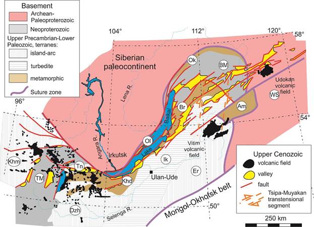
Fig. 2. Structural setting of the Late Cenozoic Baikal Rift System in the pre-Cenozoic basement. Paleomicrocontinents: TM – Tuva–Mongolian, BM – Baikal–Muya. Terranes: Dzh – Dzhida, Tn – Tunka, Khm – Khamsara, Er – Eravna, Ik – Ikat, Br – Barguzin, Ol – Olkhon, Khd – Khamar–Daban, Ok – Olokit, Am – Amalat (unclear origin), WS – West Stanovoy. The tectonic units of the basement are shown mostly after (Belichenko et al., 2006a,b), the late Cenozoic ones after (Logatchev, 1977; Rasskazov, 1996).
Рис. 2. Структурное положение позднекайнозойской Байкальской рифтовой системы в докайнозойском фундаменте. Палеомикроконтиненты: ТМ – Тувино–Монгольский, BM – Байкало-Муйский. Террейны: Dzh – Джидинский, Tn – Тункинский, Khm – Khamsara, Er – Еравнинский, Ik – Икатский, Br – Баргузинский, Ol – Ольхонский, Khd – Хамар-Дабанский, Ok – Олокитский, Am – Амалатский, WS – Западно-Становой. Тектонические единицы фундамента показаны в основном по работам (Беличенко и др., 2006a,b), позднего кайнозоя – по работам (Логачев, 1977; Рассказов, 1996).
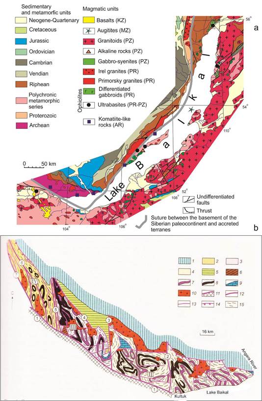
Fig. 3. Schematic geological map of the Lake Baikal coast and adjacent Tunka Valley modified after (Grudinin, Chuvashova, 2011) (a) and structural-geological scheme of the Sharyzhalgay uplift of the Siberian paleocontinent basement (Melnikov, 2011). In panal b: 1 – platform cover; 2–4 – Early Precambrian rocks of the Sharyzhalgay complex: 2 – Targazoi series, 3 – Kitoi series, 4 – Zhidoi series; 5 – Upper Archean Onot greenstone belt; 6 – Late Proterozoic rocks of fault grabens; 7–9 – marker horizons: 7 – garnet-bearing gneisses, 8 – crystalline schists and amphibolites, 9 – carbonate rocks; 10 – granitoids of the Sayan complex; 11 – Main Sayan fault; 12 – large interblock faults; 13 – undifferentiated faults; 14 – thrusts; 15 – strike of banding. The blocks are marked with Roman numerals: I – Irkut, II – Zhidoy, III – Kitoi, IV – Bulun. The numbers in circles are the faults: 1 – Main Sayan, 2 – Zazar, 3 – Dabad, 4 – Alagnino-Kholomkhinsk, 5 – Onot, 6 – Alar, 7 – Tochera.
Рис. 3. Схематичная геологическая карта побережья Байкала и сопредельной Тункинской долины. Из книги (Грудинин, Чувашова, 2011) с изменениями (a) и структурно-геологическая схема Шарыжалгайского выступа фундамента Сибирского палеоконтинента (Мельников, 2011). На панели b: 1 – платформенный чехол; 2–4 – раннедокембрийские породы Шарыжалгайского комплекса: 2 – таргазойская серия, 3 – китойская серия, 4 – жидойская серия; 5 – верхнеархейский Онотский зеленокаменный пояс; 6 – позднепротерозойские породы приразломных грабенов; 7–9 – маркирующие горизонты: 7 – гранатсодержащие гнейсы, 8 – кристаллические сланцы и амфиболиты, 9 – карбонатные породы; 10 – гранитоиды Саянского комплекса; 11 – Главный Саянский разлом; 12 – крупные межблоковые разломы; 13 – недифференцированные разломы; 14 – надвиги; 15 – простирание полосчатости. Римскими цифрами обозначены блоки: I – Иркутный, II – Жидойский, III – Китайский, IV – Булунский. Цифры в кружках – разломы: 1 – Главный Саянский, 2 – Зазарский, 3 – Дабадский, 4 – Алагнино-Холомхинский, 5 – Онотский, 6 – Аларский, 7 – Точерский.
Pre-Cenozoic basement of the Tunka Valley is composed of sedimentary, igneous, and metamorphic rocks. The Vendian-Cambrian sedimentary rocks, located in the northeastern part of the area, belong to the cover of the Tuva-Mongolian microcontinent, the Riphean basement of which includes early Precambrian blocks (Gargan and others). The sedimentary-volcanogenic rock complexes of the remaining area belong to the Khamar-Daban terrane, which accreted to the basement of the Siberian continent and the Tuva-Mongolian microcontinent in the early Paleozoic. As a result of the interaction between geological blocks, their boundary parts experienced zonal (from granulite to greenschist) metamorphism. Igneous rocks are represented by large Paleozoic granitoid massifs (Fig. 4).
The age of zonal metamorphism (ca. 488 Ma) was determined by dating syncollisional granites using the U–Pb zircon method (Kotov et al., 1997; Sal’nikova et al., 1998). For post-metamorphic gabbro-syenite massifs, Rb–Sr and U–Pb dates of about 471 Ma (Grudinin et al., 2004) and for phlogopite veins, younger Pb–Pb and Ar–Ar dates of about 460 Ma were obtained (Ivanenko et al., 1990; Reznitsky et al., 1998). Stitching complexes are: for the Hamar-Daban terrane, granites dated at 469±2 Ma (the Hamar-Daban complex); for the junction area between the Tuva-Mongolian microcontinent, the Hamar-Daban and Tunka terranes, granites dated at 481±2 Ma (the Munkusardyk complex); for the Dzhida terrane, granitoids dated at 489±2 Ma (Belichenko et al., 2006a,b; Barash et al., 2006) (Table 1).
Deep-seated inclusions in volcanic rocks – fragments of rocks from deep layers of the lithosphere, captured by magma and brought to the surface
Inclusions from volcanic rocks of the Tunka Valley exhibit deep-seated rocks extracted from layers of the earth's crust and underlying mantle by rising alkaline-basaltic magmas as they move toward the earth's surface. These characterize the transition from the mantle to the crust in the Slyudyanka metamorphic sub-terrane of the Khamar-Daban terrane.
The deep-seated inclusions are found in basalts of four sites located across the Tunka Valley strike: 1) in Khamar-Daban (Kozya Sheika between the Margasan and Zun-Murin Rivers), 2) in the south-eastern part of the Tunka Basin (northern side of the Irkut River), 3) in its north-eastern part (Khobok River), and 4) on the Tunka Range. The depths of extracted deep material consistently increase from north to south from the main relief-forming (master) fault that limits the Tunka Valley from the north, to Khamar-Daban Range (Rasskazov et al., 2010). In the Tunka Range, however, new location of spinel peridotites was found to north-east of the Arshan resort. These deep-seated rocks are compositionally similar to those from the Koziya Sheika locality on the opposite (southern) side of the Tunka Valley.
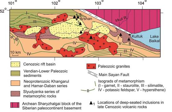
Fig. 4. Schematic geological map of the Tunka Valley and adjacent areas. The Slyudyanka terrane, affected by metamorphism under conditions of granulite facies, is traced by deep-seated inclusions from Lake Baikal to site 3 (Khobok) in the northern part of the Tunka Basin. Green fassaite clinopyroxenites occur in sites 1 and 2 (Kozya Sheika and Irkut) and, in site 4 (Bukhota) – shallow amphibole-bearing rocks, in sites 5 (Arshan), 6 (Sukhaya), and 7 (Karerny) – mainly green spinel peridotites. Metamorphic isograds are shown after (Shafeev, 1970).
Рис. 4. Схематическая геологическая карта Тункинской долины и сопредельных территорий. Террейн пород слюдянской серии, метаморфизованных в условиях гранулитовой фации, прослеживается по глубинным включениям от оз. Байкал до точки 3 (Хобок) в северной части Тункинской впадины. В местонахождениях 1 (Козья Шейка) и 2 (Иркут) находятся зеленые (фассаитовые) клинопироксениты, в местонахождении 4 (Бухота) – малоглубинные амфибол-содержащие породы, в местонахождениях 5 (Аршан), 6 (Сухая) и 7 (Карьерный) – в основном зеленые шпинелевые перидотиты. Изограды метаморфизма из работы (Шафеев, 1970).
Table 1
Age intervals of geological events to the west of Lake Baikal (eastern part of the Tunka Valley)
Таблица 1
Возрастные интервалы геологических событий на территории Западного Прибайкалья (восточная часть Тункинской долины)
|
Event |
Age, Ma |
Data source |
|
Before metamorphism of the Slyudyanka Crystal Complex: accumulation of sedimentary rocks (zircons with a relatively young age) |
800–780, 690–490 |
Kovach et al., 2013 Shkolnik et al., 2016 |
|
Peak of granulite metamorphism: syn-metamorphic granite magmatism |
488–481 |
Kotov et al., 1997; Sal’nikova et al., 1998 |
|
Post-metamorphic magmatism: gabbro-syenite massifs, phlogopite veins |
471–450 |
Grudinin et al., 2004; Sal’nikova et al., 1998; Ivanenko et al., 1990; Reznitsky., 1998 |
|
Late Paleozoic reactivation: potassic migmatization of the Khangarul series |
310 |
Savelyeva et al., 2012 |
|
Late Cenozoic rifting: basalts, sedimentary racks of rift basins |
18–12 |
Rasskazov et al., 2003 |
|
Inversion of tectonic motions in the eastern part of the Tunka Valley: cessation of volcanism, uplift of the area, formation of thrusts |
<12 |
Rasskazov et al., 2013, 2021a |
In the eastern end of the Tunka Valley, among deep-seated inclusions from tephrites of the Bystraya quarry (Levitsky et al., 2021), green spinel harzburgites, composed of yellowish-green olivine, bottle-green enstatite, and black spinel, are dominated (Fig. 5). Emerald-green Cr-diopside is rear. The rocks captured and removed from the crustal layer are black and gray, composed of augite and plagioclase (Ailow et al., 2021).
Fig. 5. Tephrite from the Bystraya quarry with deep-seated xenoliths of rocks (harzburgites) extracted from the crust–mantle transition zone.
Рис. 5. Тефрит Быстринского карьера с глубинными ксенолитами пород (гарцбургитов), отторженных от зоны коромантийного перехода.
Metamorphic rocks of crystalline basement in the Siberian paleocontinent
Metamorphic rocks (gneisses, amphibolites) of the old (Archean) crystalline basement of the Siberian paleocontinent are exposed on the Circum-Baikal Railway. Near the Kultuk village, gneisses with a pronounced gneiss texture are composed of biotite, amphibole, feldspar and quartz. These rocks of metamorphic origin were affected by pressures of up to 9 kbar and temperatures of up to 800 °C in the presence of fluids (a mixture of liquids and gases). The metamorphic rocks belong to the basement of the Siberian paleocontinent, for which detrital zircons have been dated to 3.6 billion years, and a model age of 3.82 billion years is calculated for the ore leads, corresponding to the last heavy cosmic bombardment of the Earth.
Metamorphic rocks of the Slyudyanka sub-terrane
The Slyudyanka block (metamorphic sub-terrane of the Khamar-Daban terrane) is composed of relatively young primary sedimentary rocks (sandstones, limestones) and igneous rocks (basalts, andesites) that accumulated up to 640 Ma and underwent metamorphic transformations in the presence of fluids (gas-liquid formations) at high temperatures (up to 900 °C) and pressures (up to 9 kbar). As a result, metamorphic rocks were formed: gneisses, marbles, granulites. The Slyudyanka block contains deposits of phlogopite, wollastonite, apatite, lazurite, and other gemstones. More than 200 rare minerals were found in the Pereval quarry area.
Mylonites and pseudotachylytes of the Main Sayan Fault – suture between basement of the Siberian paleocontinent and Slyudyanka sub-terrane
The Main Sayan Fault separates the metamorphic rocks of the basement of the Siberian paleocontinent from those of the Slyudyanka sub-terrane. The fault extends from the shore of Lake Baikal in a west-northwest direction over 1000 km. The width of the fault zone is from 1 to 10 km. In the area of the Kultuk village, the mylonites of the Main Sayan Fault, developed along silicate rocks, are bluish-gray schists (Fig. 6a). The strong motions were accompanied by the release of heat due to friction and melting of the material in the fault zone. These mylonites contain veins of pseudotachylytes, primarily igneous rocks that crystallized from syn-tectonic melts of basic, intermediate, and acidic composition (Rasskazov et al., 2021a) (Fig. 6b).
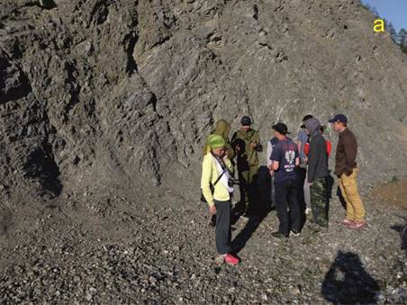
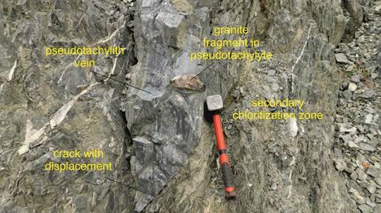
Fig. 6. Young geologists observe mylonites of the Main Sayan Fault that include veins of pseudotachylytes (a) and pseudotachylyte vein of intermediate composition in this outcrop (b). The rocks of the zone have a silicate composition and include fragments enriched in carbonate (Rasskazov et al., 2021a).
Рис. 6. Молодые геологи проводят наблюдения милонитов Главного Саянского разлома, включающих жилы псевдотахилитов (a) и псевдотахилитовая жила среднего состава в этом обнажении. Породы зоны имеют силикатный состав, а местами включают фрагменты, обогащенные карбонатом (Rasskazov et al., 2021a).
Cataclasites and mylonites of the Tunka Fault
The Tunka fault separates the Tunka Range from the basins and inter-basin isthmuses of the Tunka Valley. This fault breaks up into a series of steps descending from the top of the Tunka Range to the bottom of the valley and partially covered by its sedimentary deposits. In one of these fragments, exposed in the Arshan resort area, mylonites of the Tunka fault were formed in marbles (Fig. 7). Marble is a less resistant rock than silicate gneiss or sandstone, so there are no signs of melting of marbles due to tectonic motions. In addition, the amplitudes of displacements along the dispersed fragments of the Tunka fault were less significant than along the Main Sayan fault.
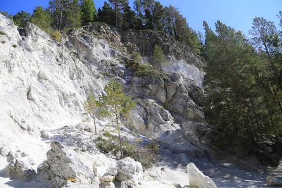
Fig. 7. Cataclasites and mylonites in marbles of the Tunka fault.
Рис. 7. Катаклазиты и милониты в мраморах Тункинского разлома.
Summary
The basins of Lake Baikal were formed along the suture zone separating the Early Precambrian basement of the Siberian paleocontinent from younger accreted terranes. The land fragment of the suture zone (the Main Sayan Fault) and its lacustrine continuation separate the Siberian paleocontinent from the Khamar-Daban Terrane and the Tuva-Mongolian microcontinent. This suture is characterized by significant movements in a strip up to 10 km wide.
The basins of the Tunka Valley inherited the interaction zone of the Khamar-Daban terrane and the Tuva-Mongolian microcontinent. This boundary is less distinct than the suture zone of the Siberian paleocontinent. The main relief-forming (master) fault of the Tunka Valley does not have a clearly expressed inheritance from any fault of the pre-Cenozoic basement and is represented by a dispersed series of low-amplitude normal faults sometimes with lateral component.
The Tunka Valley – a fragment of the Baikal Rift System
The Tunka Valley is located in the western part of the Baikal Rift System (Fig. 8a). It exhibits a chain of basins (from east to west): Bystraya, Tory, Tunka, Turan, Khoytogol, and Mondy (Fig. 8b). The basins are separated from each other’s by uplifts-isthmuses. The largest Tunka Basin (30×60 km) is separated from the Tory one by the Elovka spur and from the Turan, Khoytogol Basins by the Nilovka spur.
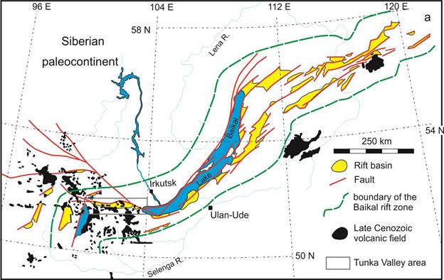
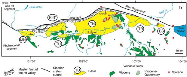
Fig. 8. The Baikal Rift System (BRS) (a) and Tunka Valley (b). The BRS includes axial basins and uplifts of the Baikal Rift Zone. The Basins: BS – Bystraya, TR – Tory, TN – Tunka, TU – Turan, KH – Khoytogol, MN – Mondy.
Рис. 8. Байкальская рифтовая система (a) и Тункинская долина (b). Байкальская рифтовая система включает осевые впадины и поднятия Байкальской рифтовой зоны. Впадины: BS – Быстринская, TR – Торская, TN – Тункинская, TU – Туранская, KH – Хойтогольская, MN – Мондинская.
Sequences of sedimentary and volcanic rocks
Stratigraphy is a section of geology that deals with sequences of sedimentary rocks. For sedimentary and volcanogenic layers, a relative geological age is determined, strata are subdivided into stratigraphic units (series, suites, horizons), and their age correlation is performed.
The chronostratigraphic scale is a geological time scale that includes the Archean, Proterozoic, Paleozoic, Mesozoic, and Cenozoic eras, built on paleontological data. In 2012, at the geological congress in Australia, many paleontologically verified boundaries were dated by radioisotope methods, so the geochronological scale got the name “chronostratigraphic”.
The Cenozoic is the era of new life on Earth that began after the great extinction 65.5 Ma that caused by a fall of a large cosmic body marked the Chuksulub crater. The Cenozoic is subdivided into the Paleogene, Neogene, and Quaternary with time boundaries of 23 Ma and 2.588 Ma, respectively. The Paleogene is subdivided into the Paleocene, Eocene, and Oligocene with time boundaries of 56 and 33.9 Ma, respectively. The Neogene is subdivided into the Miocene and Pliocene with the boundary of 5.3 Ma. The Quaternary is subdivided into the Pleistocene and Holocene with a boundary of 11.8 thousand years ago.
A suite is a basic unit of local stratigraphic subdivisions, a set of rock layers united by a common lithological composition and a presence of common fossil organic remains.
Magma is a three-component melt that consists of liquid, solid crystals, and volatile components, in both dissolved and gas-bubble forms.
Volcanism is external displaying of magmatism on the Earth that exhibits all phenomena associated with release of magma on the earth's surface. Volcano is any outlet of magma on the earth's surface. Volcanology is science that studies volcanoes.
Active volcano exhibits any form of ongoing activity, such as an eruption of lava, a gas release or seismicity.
Dormant volcano erupted in historical times (there is evidence from people in form of military reports, ancient manuscripts). There is a possibility of a future eruption of the volcano.
Extinct volcano is unlikely to ever erupt again. Extinct volcanoes exist as remnants of volcanic conduits or spatially associated lava flows.
In the Tunka Basin and adjacent part of the Elovka Spur, volcanic intervals obtained through K–Ar dating are 1) 16–8 Ma (Middle and Upper Miocene), 2) 4.0–2.4 Ma (Pliocene), and 3) 1.7–0.8 Ma (Pleistocene) (Figs 8a,b). Age estimates of lava beds in the borehole, given in Fig. 9,, are proposed from dating of basalts in outcrops and the K–Ar age of ca. 1.6 Ma obtained for volcanoes crowning the sequence, recorded by the deep borehole P-2 in 1956. In the southern part of the Tunka Basin, the Zhemchug borehole also showed an Oligocene sedimentary sequence, dated by the spore-pollen complex (Mazilov et al., 1993).
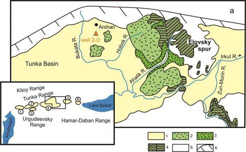
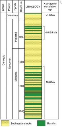
Fig. 9. Distribution of basalts of different ages in the Tunka Basin and on the Elovka Spur (a) and distribution of basalts in the volcano-sedimentary filling of the northeastern part of the Tunka Basin (well 2-О) (b). Panel (a): 1 – Quaternary deposits; 2 – Pliocene-Quaternary basalts; 3 – Neogene sedimentary deposits; 4 – Miocene basalts: lower (a) and upper (б) strata; 5 – rocks of the crystalline basement; 6 – normal-strike-slip scarp of the Tunka Range (dashes indicate the direction of movement of the fault wings). The numbers in circles in the inset indicate dry valley basins: 1 – Mondy, 2 – Khoytogol, 3 – Turan, 4 – Tunka, 5 – Tory, 6 – Bystraya. The well was drilled 7 km south of the Arshan spar (open file report by A.S. Povyshev, 1956).
Рис. 9. Распределение разновозрастных базальтов в Тункинской впадине и на Еловском отроге (a) и распределение базальтов в вулканогенно-осадочном заполнении северо-восточной части Тункинской котловины (скважина 2-О) (b). 1 – четвертичные отложения; 2 – плиоцен-четвертичные базальты; 3 – неогеновые осадочные отложения; 4 – миоценовые базальты: нижняя (а) и верхняя (б) толщи; 5 – породы кристаллического фундамента; 6 – сбросо-сдвиговый уступ Тункинских гольцов (штрихи указывают направление движения крыльев разлома). Цифрами в кружках на врезке обозначены суходольные впадины: 1 – Мондинская, 2 – Хойтогольская, 3 – Туранская, 4 – Тункинская, 5 – Торская, 6 – Быстринская. Скважина пройдена в 7 км южнее курорта Аршан (отчет А.С. Повышева 1956 г.).
The Miocene volcanic eruptions correspond to accumulation of the coal-bearing Tankhoi suite, the Pliocene and Early Pleistocene ones correspond to the Anosovka suite. In the Late Pleistocene and Holocene, volcanism stopped. In the Pliocene, the Tunka Ridge grew rapidly and was dissected by erosion. Coarse-grained material was transported away from the ridge into the valley. A 200-meter coarse-grained layer of the Anosovka suite accumulated without basalt interlayers. The Early Pleistocene volcanic eruptions in the Tunka Basin are separated from the Pliocene ones by a lull in the time interval of 2.4–1.7 Ma. Early Pleistocene volcanism finalized about 0.9–0.8 Ma due to a general change of the structural evolution in the central part of the Baikal Rift System – the Tunka Valley and Lake Baikal basins.
Some of the Pleistocene volcanic cones are located at the bottom of the Tunka Basin (Fig. 10a). The highest of them, the Khara-Boldok volcano (Fig. 10b), is 120 m high. Volcanic rocks are observed in outcrops: 1) on the Khurai-Khobok volcano and 2) on the left bank of the Irkut River.
The Khurai-Khobok volcano is located 7 km south of the village of Arshan, next to the Kultuk-Arshan highway. A low (20–25 m) cone of scoria and agglutinates of red, yellow, and black colors is exposed by quarries. The crater, which was used to extract scoria during construction, is one of the quarries (Fig. 10c). The scoria are cut by basalt dikes up to 1 m thick. The dikes extend from south to north. The age of the volcano is ca. 1.6 Ma. Basalts have reverse polarity of the Matuyama chron (determinations of V.A. Kravchinsky). The slopes of the Khurai-Khobok volcano are covered with loess, forming a homogeneous layer and a heterogeneous layer containing inclusions of scoria. The homogeneous layers loesses exceed 3 meters in low places, the heterogeneous layer does not exceed 0.5 m (Fig. 10d).
A fragment of the lava cover covering the slope of the Elovka spur is observed on the left bank of the Irkut River. A basalt layer of 2.4 Ma lays on sands. Black basalt, with thick-columnar jointing in the flow, contains inclusions of green clinopyroxenites (pyroxene – fassaite) and megacrysts of augite and plagioclase. The sand underlying the lava flow is fine-medium grained, similar to the modern sand of the Irkut River. It is burnt by lava – has a red color at the contact (Fig. 10e).
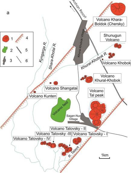
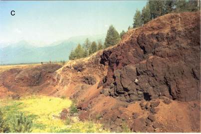
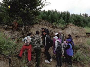
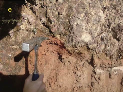
Fig. 10. Scheme of Pleistocene volcanic edifices of the Tunka Basin (a), Khara-Boldok volcano (b), Pyroclastics (slags and agglutinates) of the Khurai-Khobok volcano, exposed by a quarry (c), young geologists on the loess cover of a slope on the Khurai-Khobok volcano (d), and ocherous burnt sand at the base of a basalt flow (e). In panel (a): 1 – volcanic cone; 2 – lavas; 3 – settlement; 4 – lateral boundaries of a local volcanic zone; 5 – main road; 6 – country road. The scheme was compiled by schoolchildren as part of the work of the Lazurit Children's Center of School No. 7 in the Kultuk village (Grudinin, Chuvashova, 2011).
Рис. 10. Схема плейстоценовых вулканических построек Тункинской впадины (a), вулкан Хара-Болдок (b), Пирокластика (шлаки и агглютинаты) вулкана Хурай-Хобок, вскрытые карьером (с), молодые геологи на лёссовом покрове склона вулкана Хурай-Хобок (d) и охристый обожженный песок в подошве базальтового потока (e). На панели (а): 1 – вулканический конус; 2 – лавы; 3 – селение; 4 – латеральные границы локальной вулканической зоны; 5 – дорога главная; 6 – дорога проселочная. Схема составлена школьниками в рамках работы Детского центра «Лазурит» школы № 7 п. Култук (Грудинин, Чувашова, 2011).
In addition to the volcanic rocks of the Tunka Basin, volcanic rocks are exposed in the Bystraya quarry, on the isthmus between the Tory and Bystraya Basins, and in the western shore of Lake Baikal, in the Kultuk area. In the former site, the lava cover of tephrite composition has a thin-columnar joint. The visible layer is up to 15 m thick (Fig. 11a). The age of the tephrites is ca. 13 Ma. In the latter, lava eruptions, occurred into water in lower places, resulted in hyaloclastite and pillow-lava accumulation (Fig. 11b). Simultaneously, the Kultuk volcano produced lavas erupted in ground conditions that are exposed in higher elevations of relief at the Obruchev fault outcrop (Fig. 11c).
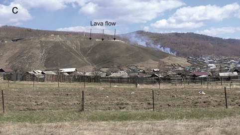
Fig. 11. Tephrite flow with columnar jointing exposed in the wall of the Bystraya quarry (a), fragment of an outcrop with pillow lavas alternating with hyaloclastites in the Kultuk volcano (b), and lava flow position on a ledge that exposed in scarp of the Obruchev fault in the north-eastern portion of the Kultuk settlement (c). In panel (b), railway cut exposes tilted layers of lavas and clastic glassy volcanic material (Rasskazov et al., 2013).
Рис. 11. Поток тефритов со столбчатой отдельностью, вскрытый в стенке Быстринского карьера (a), фрагмент обнажения подушечных лав, перемежающихся с гиалокластитами на Култукском вулкане (b) и положение фрагмента лавового потока в уступе Обручевского разлома в северо-восточной части пос. Култук (с). На панели (b) отложения вскрыты железнодорожной выемкой. Различаются наклоненные слои лавового и обломочного стекловатого вулканического материала (Рассказов и др., 2013).
Along the Obruchev fault of the South Baikal Basin, the vertical amplitude of the Cenozoic motions exceeds 4 km. Fig. 12 demonstrates location of the Kultuk volcano on a branch of the Obruchev fault, degenerating along its strike. The rapid attenuation of the amplitude of vertical displacements along the fault from east to west, accompanied by an inclination of the surface of the volcano block to the east, indicates a hinge kinematics of the tectonic motions.
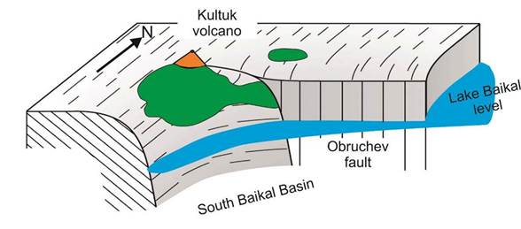
Fig. 12. Schematic block–diagram shows a hinge tectonic tilt of a lava surface and subvolcanic part of the Kultuk volcano towards the South Baikal basin at its western circuit.
Рис. 12. Схематичная блок–диаграмма иллюстрирует шарнирный тектонический наклон лавовой поверхности и субвулканической части Култукского вулкана к Южно-Байкальской впадине на ее западном замыкании.
The Tunka Valley inherits an old lithospheric boundary of crust–mantle transition (CMT): crustal versus mantle events of 2.44–2.22 and 1.63–1.31 Ga at the junction between Khamar-Daban terrane, Tuva-Mongolian microcontinent, and Siberian paleocontinent
The Tunka Valley is located between the Tuva-Mongolian microcontinent and Khamar-Daban terrane that are known as major tectonic units accreted to the Siberian paleocontinent. We report 207Pb/206Pb ages of 2.44–2.22 Ga for sources of Late Cenozoic volcanic rocks from the Tunka volcanic zone and of 1.63–1.31 Ga for those from the Khamar-Daban one. The new ages are consistent with Precambrian geological events that are characteristic of the area and contradict the Early Paleozoic collisional connection between these tectonic units inferred from dating of syn-collisional granites on the crustal level.
We constrain ore-forming processes in the Gargan block of the Tuva-Mongolian microcontinent and in the south of the Siberian paleocontinent between 2.45 and 1.4 Ga and between 1.3 and 0.25 Ga, respectively (Rasskazov et al., 2010). The latest Pb-separating event in the Gargan block was followed by the generation of restite ultrabasic Ilchir belt that bounds the block from the south (Kiseleva et al., 2020). So, we trace the boundary between the Gargan block and Ilchir belt to magma sources of the Tunka and Khamar-Daban zones that reasonably denote the root part of the Khamar-Daban terrane, accreted to the Tuva-Mongolian microcontinent and Siberian paleocontinent 1.63–1.31 Ga ago (Fig. 13).
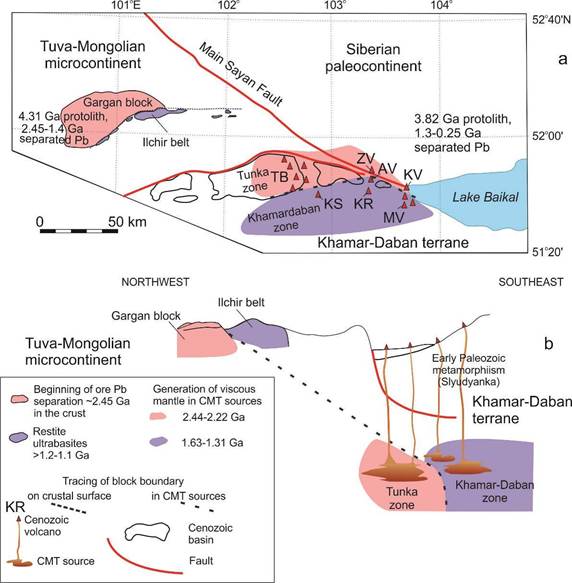
Fig. 13. Tracing of the Gargan block – Ilchir belt boundary to CMT (crust–mantle transition) sources for Cenozoic volcanic rocks from the Tunka and Khamar-Daban zones in sketch map (a) and section (b). Volcanoes of the Tunka zone: TB – Tunka Basin group, ZV – Zyrkuzun, KV – Kultuk. Volcanoes of the Khamar-Daban zone: KS – Kozya Sheika, KR – Karyerny, AV – Anchuk, MV – Meteo.
Рис. 13. Трассирование мезопротерозойской границы Гарганского блока – Ильчирского пояса гипербазитов к источникам коромантийного перехода (КМП) позднекайнозойских вулканических пород Тункинской зоны на карте–схеме (a) и в разрезе (б). Вулканы Тункинской зоны: TB – группа Тункинской впадины, ZV – Зыркузунский, KV – Култукский. Вулканы Хамардабанской зоны: KS – Козья Шейка, KR – Карьерный, AV – Анчукский, MV – Метео.
The Tunka and Khamar-Daban terranes were considered as a single unit together with the Tuva-Mongolian massif (Khain et al., 1995) or as geologically different geological blocks (Belichenko et al., 2006). Taking into account the metamorphic content of the Khamar-Daban terrane, we consider it as a result of the generation of the Earth's continental lithosphere during the convergence of continental blocks. An idealized collisional orogen is limited by oppositely descending oceanic slabs (Fig. 14a). Its cross-section contains structural, sedimentary, petrological, and metamorphic features of processes of different ages. Fragments of old accretionary orogens participated in later collisional mountain building are found in younger collisional terranes (Kusky et al., 2016; Windley et al., 2021). Deep geological structures of the counter slabs are defined in seismic tomographic models of the Tien Shan and Himalayan-Tibetan orogens (Gao et al., 2013; Li et al., 2009). In the upper part of the north-south MANAS profile (Tien Shan), the width of the slab zone is about 400 km. At a depth of ~300 km, the width decreases to 250 km. Stagnant paleoslab fragments are interpreted as fragments of the lithosphere of the Turkestan paleoocean that closed in the Late Paleozoic.
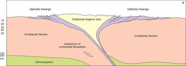
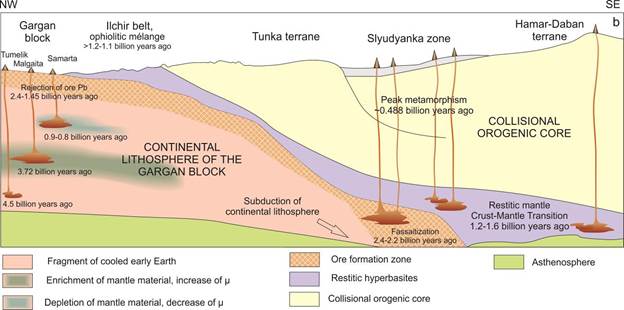
Fig. 14. Schematic section of an ideal collisional orogen bounded by opposing slabs (a) and schematic section of the Ilchir-Tunka paleosubduction zone (b). In panel (a) – simplified version of the scheme from (Kusky et al., 2016), in panel (b) – the youngest events, associated with the Ilchir-Tunka slab, probably took place 0.9–0.8 Ga ago.
Рис. 14. Схематичный разрез идеального коллизионного орогена, ограниченного встречными слэбами (а) и схематичный разрез Ильчиро-Тункинской палеосубдукционной зоны (б). На панели (а) – упрощенный вариант схемы из работы (Kusky et al., 2016), на панели (b) – yаиболее молодые события, связанные с Ильчиро-Тункинским слэбом, возможно, имели место 0.9–0.8 млрд лет назад.
We emphasize the importance of ore-forming events in the Gargan block, launched about 2.45 Ga, simultaneously with source generation in the Tunka zone. Basalts of this zone include xenoliths of fassaitic clinopyroxenites that show wide variations in the oxidation–reduction state. We suggest that fassaite (diopside) mineralization was due to interaction between orthopyroxene and calcite: (Mg, Fe)2Si2O6 + CaCO3 → (Mg, Ca)2Si2O6 + CO2 + FeO. Orthopyroxene of high-Mg spinel harzburgite xenoliths from Khobok River lavas (Tunka basin) shows SiO2 content as high as 58.7 wt. %, while fassaite from pyroxenite xenoliths has SiO2 content as low as 49 wt. %. Fassaitization of orthopyroxenites and harzburgites, obviously, releases both iron and silica. These components are found as amorphous Fe–Si phases in metasomatite xenoliths with low Mg/Si and Al/Si ratios (Ailow et al., 2021a,b).
From data obtained, we speculate that fassaitization was an effective crust–mantle process of 2.4–2.2 Ga that could provide both the deep-seated Fe–Si mineralization and generation of banded iron formation (BIF) widely displayed in the Great Oxidation Event of the Earth (Yokota et al., 2013; Bindeman et al., 2016; Eguchi et al., 2020). Ore Pb was separated in the Gargan block before the formation of the hyperbasite mélange of the Ilchir belt. Respectively, the boundary of the Gargan block and the Ilchir hyperbasite belt is traced to the CMP sources of the Tunka zone that marks the root boundary part of the Khamar-Daban accretion-collision (metamorphic) core (Fig. 14b).
Summary
The Late Cenozoic development of the Tunka Rift Valley is traced by sedimentary deposits of the Tankhoi coal-bearing suite, ocherous coarse-grained Anosovka suite, and sand suite accumulations. Volcanism of 16–8 Ma (middle-late Miocene), occurred in the Tunka Basin and adjacent part of the Elovka spur, was followed with 4.0-2.4 Ma (Pliocene) and 1.7-0.8 Ma (Early Pleistocene) volcanic eruptions. The eastern end of the Tunka Valley was affected by extension and volcanism between 18 to 12 Ma. The later compression of the crust in this area resulted in its uplift and erosion and also in cessation of volcanic eruptions.
Volcanic rocks contain deep-seated inclusions extracted by ascending magmas from deep lithospheric layers of the Earth. These yield information on rock compositions of the earth's interior in the zone of the crust–mantle transition of the Slyudyanka metamorphic sub-terrane of the Khamar-Daban terrane.
From Pb isotope estimates of ages for mantle sources of rift-related Cenozoic volcanic rocks, we infer that the Tunka Valley inherits an old lithospheric boundary of the CMP that is marked by events of 2.44–2.22 and 1.63–1.31 Ga at the junction between Khamar-Daban terrane, Tuva-Mongolian microcontinent, and Siberian paleocontinent. The former time interval is critical for ore mineralization in the Archean Gargan block.
Mineral waters of the Tunka Valley and the water of the southern Lake Baikal
Hydrogeology is a section of geology that studies groundwaters, their resources, spatial distribution of their components, interaction between groundwater and host rocks, as well as the economic importance of groundwater components and the impact on them of human activity (Fundamentals ..., 1980).
A mineral spring is an outlet of groundwaters with a mineralization of more than 1 g/dm3. Fresh waters have a mineralization of less than 1 g/dm3.
Discovery and study of Arshan mineral waters
Mineral springs of the Arshan resort were found by a hunter Terenty Chemezov from the Taly settlement at the end of the 19th century (in 1896). He told the priest of the Talsk church, Yakov Chistokhin, about his discovery, who helped spread information about the healing properties of the Arshan mineral waters and took steps to develop them for medicinal purposes. In Arshan, wells were drilled since 1931. A complete information on mineral spring distribution in the Tunka Basin was delivered by employees of the Tunka National Park, A.M. Lekhatinov and E.B. Lekhatinova (2008) (Fig. 15).
Fig. 15. Spatial distribution of mineral springs in the Tunka Basin (Lekhatinov, Lekhatinova, 2008).
Рис. 15. Пространственное распределение минеральных источников в Тункинской впадине (Лехатинов, Лехатинова, 2008).
Compositions of mineral waters
Waters from wells drilled in the Arshan resort is defined as carbonic hydrocarbonate magnesium-calcium, weakly ferrous. Seepage of mineral waters in the Tunka fault zone led to the deposition of black graphite and the release of plate crystals of gypsum (sulfate), up to 3 cm in size. Current generation of these minerals is observed in cataclastic and mylonitized marbles (Fig. 16).
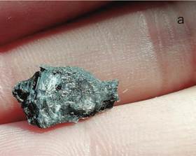
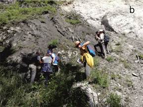
Fig. 16. Gypsum crystal from graphitized marble (a) and young geologists on the outcrop of the zone of black graphitized marble (black) on background of white marble that is cataclased and mylonitized (b).
Рис. 16. Кристалл гипса в графитизированном мраморе (a) и молодые геологи на обнажении зоны черного графитизированного мрамора (черное) на фоне белого мрамора, катаклазированного и милонитизированного (b).
Distribution of thermal and cold groundwaters
In the active Tunka fault zone, at the Arshan resort, there are numerous outlets of fresh water springs directly in the bed of the Kyngarga River and its sides. Thermal waters come from wells. The water can be drunk to improve the functioning of the gastrointestinal tract. The well reached a layer of carbonates with a temperature of 45 °C.
During the entire study of the mineral waters, about 40 wells were drilled. Cold mineral waters are spatially separated from hot ones. They differ from each other in the U content and 234U/238U activity ratio (AR4/8) (Fig. 17).
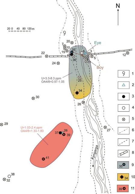
Fig. 17. Differences in uranium components in cold and hot mineral waters on sketch-map of water sites in the Arshan resert. 1 – fresh water source; 2 – mineral water source; 3 – mineral water well; 4 – abandoned well; 5 – closed well; 6 – boundary of the 2nd floodplain terrace; 7 – boundary of the 1st floodplain terrace; 8 – Tunka fault line; 9–11 – areas of extracting cold (9) and warm (mothballed well) (10) carbon dioxide waters with uranium close to isotopic equilibrium and hot carbon dioxide waters with nonequilibrium U (11). Schematic map is adopted from (Kustov et al., 2002) with additions.
Рис. 17. Различие урановых компонентов в холодных-теплых и горячих минеральных водах на схеме расположения водопунктов на курорте Аршан. 1 – источник пресной воды; 2 – источник минеральной воды; 3 – скважина минеральной воды; 4 – ликвидированная скважина; 5 – закрытая скважина; 6 – граница 2-ой надпойменной террасы; 7 – граница 1-ой надпойменной террасы; 8 – линия Тункинского разлома; 9–11 – ареалы извлечения холодных (9) и теплых (законсервированная скважина) (10) углекислых вод с ураном, близким к изотопному равновесию, и горячих вод с неравновесным U (11). Использована схема расположения водопунктов (Кустов и др., 2002).
The origin of mineral waters
The hydrogeological section of the Arshan carbonate water deposit area, published in 1968 (Pinnecker et al., 1968), schematically demonstrates the transition from the Tunka basin to the side of the valley, mainly composed of carbonate deposits alternating with crystalline schists and gneisses and a single granite intrusion (Fig. 18a).
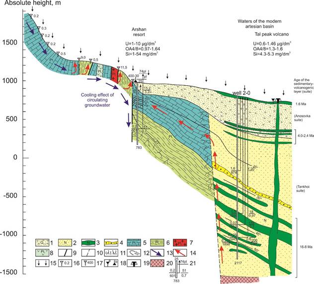
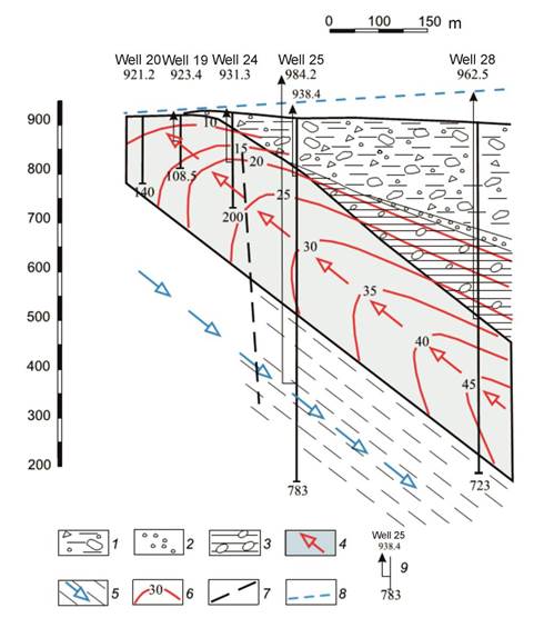
Fig. 18. Hydrogeological section of the northern part of the Tunka Basin in the area of the Arshan deposit of carbon dioxide waters (scheme of formation of carbon dioxide waters) (a) and hydrodynamic scheme of the Arshan carbonate water deposit (Pavlov et al., 2018) (b). In panel (a): 1 – Quaternary boulder and sand-pebble deposits; 2 – Neogene sands and sandstones; 3 – Neogene basalts; 4 – sandstones; 5 – crystalline limestones and dolomites; 6 – crystalline schists; 7 – gneisses; 8 – hornblende granites; 9 – aquiferous faults and tectonic contacts; 10 – paths of ascending movement of carbon dioxide waters along the supposed fault zone; 11 – zones of increased fracturing; 12 – thermal isohypses; 13 – assumed direction of movement of carbon dioxide waters; 14 – direction of fresh water movement from the recharge area to the discharge zones; 15 – atmospheric precipitation: 16–18 – springs (the number next to the spring is the flow rate, l/sec): 16 – fresh fissure water; 17 – fresh fissure-vein water; 18 – mineral springs: a – hydrogen-sulfa; b – carbon dioxide; 19 – Quaternary volcano; 20 – basement (from geophysical data); 21 – well, above – well number, below – depth, m: in the numerator – flow rate, l/sec, denominator – depth of water opening, m; on the right in the numerator – excess, m, in the denominator - mineralization, g/l; arrow – pressure above the roof of the aquifer, the number above it is the piezometric level, m; 13 – direction of carbon dioxide water movement; 14 – direction of fresh water movement from feeding areas to discharge zones. The section is modified after (Pinneker et al., 1968). For the upper part of the section of borehole 2-O, the column of the section of the primary records was used (Povyshev, 1956). Age estimates of the lava packages are given on the basis of K–Ar ages of basalts in outcrops of the Elovka spur and determinations of the K–Ar age of ~1.6 Ma for volcanoes finalizing the lava sequence in the northeastern part of the Tunka depression, which underwent tectonic inversion with an uplift of the area relative to the bottom of the Tunka basin (Rasskazov, 1993). Panel (b) compiled on basis of the M.A. Kashina scheme. 1–3 – deposits: 1 – boulder-pebble, 2 – gruss-pebble, 3 – clays with inclusions of pebbles and boulders; 4–5 – ascending flow of dioxide carbonate waters in carbonate deposits of the Irkut (?) suite (4) and descending flow of nitrogen waters in metamorphic schists of the Ilchir (?) suite (5); 6–9 – other designations: isotherm (6), inferred fault (7), piezometric groundwater level (8), well (9).
Рис. 18. Гидрогеологический разрез северной части Тункинской впадины в районе Аршанского месторождения углекислых вод (схема формирования углекислых вод) (a) и гидродинамическая схема Аршанского месторождения углекислых вод (Павлов и др., 2018) (b). 1 – валунно- и песчано-галечниковые отложения четвертичного возраста; 2 – пески и песчаники неогена; 3 – базальты неогена; 4 – песчаники; 5 – кристаллические известняки и доломиты; 6 – кристаллические сланцы; 7 – гнейсы; 8 – роговообманковые граниты; 9 – водоносные разломы и тектонические контакты; 10 – пути восходящего движения углекислых вод по предполагаемой зоне разлома; 11 – зоны повышенной трещиноватости; 12 – термоизогипсы; 13 – предполагаемое направление движения углекислых вод; 14 – направление движения пресных вод от области питания к зонам разгрузки; 15 – атмосферные осадки: 16–18 – родники (цифра у родника – дебит, л/сек): 16 – пресных трещинных вод; 17 – пресных трещинно-жильных вод; 18 – минеральные источники: а – сероводородные; б – углекислые; 19 – четвертичный вулкан; 20 – фундамент (по геофизическим данным); 21 – скважина, наверху – номер скв., внизу – глубина, м: в числителе – дебит, л/сек, знаменателе – глубина вскрытия воды, м; справа в числителе – превышение, м, в знаменателе – минерализация, г/л; стрелка – напор над кровлей водонапорного горизонта, цифра над ней – пьезометрический уровень, м; 13 – направление движения углекислых вод; 14 – направление движения пресных вод от области питания к зонам разгрузки. Разрез из работы (Пиннекер и др., 1968) с изменениями. Для верхней части разреза скв. 2-О использована колонка разреза первичной документации (Повышев, 1956). Возрастные оценки лавовых пачек даны на основе K–Ar датирования базальтов в обнажениях Еловского отрога и определениях K–Ar возраста ~1.6 млн лет вулканов, венчающих последовательность лав в северо-восточной части Тункинской впадины, претерпевшей тектоническую инверсию с поднятием территории относительно днища Тункинской впадины (Рассказов, 1993). На панели (b) дана интерпретация М.А. Кашиной. 1–3 – отложения: 1 – валунно‐галечные, 2 – дресвяно‐галечные, 3 – глины с включением гальки и валунов; 4–5 – восходящий поток углекислых вод в карбонатных отложениях иркутной (?) свиты (4) и нисходящий поток азотных вод в метаморфических сланцах ильчирской (?) свиты (5); 6–9 – прочие обозначения: изотерма (6), предполагаемый разлом (7), пьезометрический уровень подземных вод (8), скважина (9).
After pioneering studies by E.V. Pinneker and other hydrogeologists, S.Kh. Pavlov et al. (2018) also suggested that groundwaters of the Tunka Basin are formed in deep horizons of the both sedimentary strata and crystalline basement. These authors considered groundwaters as representing a single hydrodynamic system, the development of which was determined by water infiltration from the feeding areas of the surrounding mountain ranges. Simultaneous downward movement of nitrogenous and upward movement of carbonated thermal waters was proposed at various hypsometric levels of the hydrogeological section of the Tunka Basin (Fig. 18b).
Hydrogeochemical data
The origin of groundwaters can be substantiated by study of chemical elements and isotopes. From Sr- and H-isotope systematics, mineral waters from the Tunka Basin were considered as derivatives of meteoric precipitation (Dril et al., 2005). New data characterize mainly groundwaters of the upper hydrogeodynamic stage of the crust at depths of up to 1.6 km. The work includes a single sample of station 2 from a deeper level (from the lower hydrogeodynamic stage) – a sample of cold carbonated mineral water from the Arshan resort. The point of this mineral water corresponds to the trend of the thermal waters of the Baunt Basin of the BRS. In contrast to the trends of increasing δ2Н and δ18О with increasing Si (i.e. with increasing temperature) in the Kultuk reservoir of the upper hydrogeodynamic stage, in the Baunt reservoir of thermal waters of the lower hydrogeodynamic stage, trends of decreasing δ2Н and δ18О with increasing Si (i.e. with increasing temperature) are observed (Fig. 19).
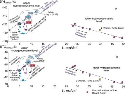
Fig. 19. Diagrams δ2Н vs Si (a) δ18О vs Si (б) comparing data obtained for groundwaters of the Kultuk area, northwest coast of Lake Baikal, and Irkutsk reservoir with data on thermal waters of the Baunt Basin (BRS). Sampling sites of the BRS are shown in (Rasskazov et al., 2025a). Data on thermal waters from the Baunt Basin are from (Zamana, 2011).
Рис. 19. Диаграммы δ2Н – Si (a) δ18О – Si (б) сравнения данных, полученных для подземных вод Култукского полигона, северо-западного побережья Байкала и восточного побережья Иркутского водохранилища с данными о термальных водах Баунтовской впадины (БРС). Территории опробования подземных вод БРС обозначены в работе (Рассказов и др., 2025a). Для Баунтовской впадины использованы данные из работы (Замана, 2011).
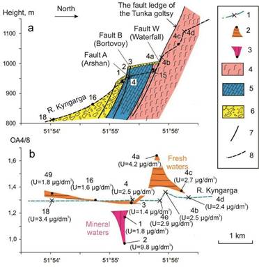
Fig. 20. Water sampling points on the geological profile along the Kyngarga River (a) and variations in AR4/8 and U concentration in surface and groundwater samples along the profile (b) in 2012–2014. 1 – sampling points in the river; 2 – the same in springs with AR4/8 values exceeding those in river samples; 3 – the same in springs with AR4/8 values lower than those in river samples; 4 – silicate rocks (granite gneisses); 5 – carbonates; 6 – boulder pebbles; 7 – faults; 8 – thalweg profile of the river valley. The measured U concentrations are given in brackets under each sampling point on profile a.
Рис. 20. Точки отбора проб воды на геологическом профиле р. Кынгарга (а) и вариации ОА4/8 и концентрации U в пробах поверхностных и подземных вод вдоль профиля (б) в 2012–2014 гг. 1 – точки отбора проб из реки; 2 – то же из родников со значениями ОА4/8, превышающими значения этого отношения в пробах из реки; 3 – то же из родников со значениями ОА4/8, более низкими, чем значения этого отношения в пробах из реки; 4 – силикатные породы (гранитогнейсы); 5 – карбонаты; 6 – валунные галечники; 7 – разломы; 8 – профиль тальвега речной долины. В скобках под номерами точек отбора проб на профиле а приведены измеренные концентрации U.
Mineral waters come to the surface along the active Tunka fault. Its activities result in displacements of the modern terrace of the Kyngarga River over first tens of meters. The distribution of uranium components and Si in the Arshan mineral waters contradicts the hypothesis of their movement along the carbonate aquifer and is better explained by the hypothesis of spatial separation of cold and hot carbonic waters from a deep reservoir (Fig. 21).
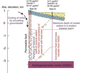
Fig. 21. Scheme of the proposed spatial separation of cold and hot carbon dioxide waters of the Arshan field. In a carbonate layer (blue bricks), partially covered by Cenozoic sediments (yellow background with dots and circles), wells extract mineral waters that rise from a hydrogeodynamic center (HGDC) and periphery a reservoir in a permeable fault and from the same HGDC at some distance from it (Rasskazov et al., 2024).
Рис. 21. Схема предполагаемого пространственного разделения холодных и горячих углекислых вод Аршанского месторождения. В слое карбонатов (синие кирпичики), частично перекрытых кайнозойскими осадочными отложениями (желтый фон с точками и кружками), скважинами вскрываются минеральные воды, которые поднимаются из гидрогеодинамического центра (ГГДЦ) и периферии резервуара в проницаемом разломе и из этого же ГГДЦ в удалении от него (Рассказов и др., 2024).
High 3Не/4He ratio and cyclic equilibrium of 234U/238 ratio in groundwaters from the Tunka Basin
Gas emissions in the Arshan and other mineral waters from the Tunka Basin yield unusually high 3Не/4He ratio (10–5). The Tunka Basin is the only place in Asia, where such a high helium isotope ratio has been determined (Polyak, 2003). In mineral waters from carbonates in the Olkha well in the south of the Siberian paleocontinent, AR4/8 varies from 11.82 to 15.71. Eight atoms of 4He are formed during the radioactive decay of uranium-238 to the final stable isotope 206Pb. Although, in addition to the decay of 238U, 4He is generated during the radioactive decay of 235U and 232Th, the distribution of radiogenic 4He is associated primarily with the radioactive decay of 238U. The revealed sharp difference in the isotopic ratio 3He/4He in the gas phase associated with groundwater of the Siberian Paleocontinent and Tunka Basin (Polyak, 2003) is consistent with the difference in AR4/8 of mineral waters of the Siberian Paleocontinent and the Arshan deposit of the Tunka Basin (Fig. 22).
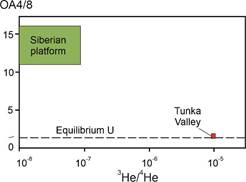
Fig. 22. Difference of AR4/8 in carbon dioxide mineral waters and 3He/4He in gases of carbon dioxide waters from wells in the Siberian paleocontinent and Tunka basin. Typical AR4/8 ranges are from (Rasskazov et al., 2024), those of 3He/4He values are from (Polyak, 2003).
Рис. 22. Различие ОА4/8 в углекислых минеральных водах и 3He/4He в газах углекислых вод из скважин на Сибирской платформе и в Тункинской впадине. Интервалы типичных значений ОА4/8 из статьи (Рассказов и др., 2024), интервалы значений 3He/4He – из статьи (Polyak, 2003).
In mineral waters from carbonates in the Olkha well, U isotopes change due to chemical dissolution of carbonates. Mineral water is enriched in 234U recoil atoms similar to the dissolving macro- and microcomponents of carbonates, while AR4/8 is complicated by the dependence of U dissolution on the oxidation-redox potential (ORP). In 2013–2015, AR4/8 of mineral waters from the Olkha well increases with a decrease in U concentration under the action of a reducing agent, and does not change in 2017–2022 with an increase in its concentration under the action of an oxidizing agent (Rasskazov et al., 2024). Under oxidizing conditions, uranium dissolves in water and is carried away. If a reducing gas (H2, H2S, etc.) acts, some uranium is retained in the rock that leads to the effect of creating an excess of 234U. In the Olkha well, there is no mechanism for replenishing the deep reservoir with water. Due to the retention of water in shallow carbonates (water with a low Si content), the effect of excess 234U accumulation is clearly displayed.
The lack of excess 234U isotope in the Arshan mineral waters, derived from carbonates, is explained by the effect of a strong oxidizer (for example, CO2). Uranium is constantly brought by water to the depth of well invasion from a deep reservoir, in which it is in isotopic equilibrium, therefore the products of radioactive decay of 238U do not accumulate in shallow carbonate rocks and the effect of excess 234U accumulation is not provided.
The high isotope ratio 3Не/4He in the Arshan and other mineral waters of the Tunka Basin corresponds to the value of the shallow mantle. Therefore, gas phase of the CMP zone penetrates here through the crust at present. As soon as the crust is permeable for gas, it might be permeable for basaltic melts. So, volcanic eruptions might happen. The probable eruption site is the south-north Kyngarga fault (Fig. 23).
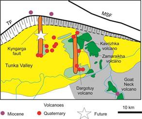
Fig. 23. Spatial position of the probable future volcanic eruption in the Kyngarga fault zone. Symbols are as in Fig. 8b. Faults: TF – Tunka Fault, MSF – Main Sayan Fault (Rasskazov et al., 2024).
Рис. 23. Пространственное положение вероятного будущего вулканического извержения в зоне Кынгаргского разлома (Рассказов и др., 2024). Условные обозначения см. рис. 8b. Разломы: ТF – Тункинский, MSF – Главный Саянский.
Water of the South Baikal Reservoir (SBR)
Lake Baikal is the largest reservoir of liquid fresh water on the planet. The lake's water makes up about 20% of the world's surface water reserves, excluding glaciers, snowfields, and ice in Antarctica, Greenland, and other reserves where the water is in a solid state (Galaziy, 1984). Under the current dynamics of water exchange, a complete replacement of the huge reservoir of Lake Baikal (23.6 thousand km3) would take no more than 400 years (Votintsev, 1961).
Water of Lake Baikal has a weakly mineralized composition (total dissolved solids (TDS) of about 100 mg/dm3). The South Baikal Reservoir (SBR) – deep waters from the South Baikal Basin – yields a homogeneous composition of U and Sr isotopes: U = 0.45 μg/dm3, the activity ratio 234U/238U = 1.96 ± 0.80 (± 1σ); Sr = 99 μg/dm3, 87Sr/86Sr = 0.708629 ± 0.000009 (± 2σ). The uniqueness and consistency of the isotopic composition in the volume of the SBR opens up the possibility of its identification as a component of the groundwater along the Baikal coast (Rasskazov et al., 2020).
The TDS of waters from the South Baikal reservoir is approximately 10 times lower than the mineralization of the Arshan resort waters (average TDS is about 1 g/dm3, maximal – up to 4 g/dm3).
Summary
In the Tunka Basin, mineral waters have been known since 1896. These were studied at different times by hydrogeologists using various methods. In the recent paper, S.Kh. Pavlov et al. confirmed the hypothesis on the simultaneous downward movement of nitrogen and upward movement of carbon dioxide thermal waters at different levels of the hydrogeological section in the Tunka Basin. Variations of chemical elements and U–He–O–H isotopes indicate more complex relations between groundwater components with the participation of both meteoric waters and fluids rising from the crust-mantle transition zone.
Dangerous geological processes
Geological processes last for millions and billions of years, but sometimes they are replaced by rapid phenomena, reflected in large-scale movements of blocks, the formation of mountains and the filling of basins with coarse-grained sediments. Such rapid processes include earthquakes and mudflows that have catastrophic consequences for humans.
Earthquake is an underground shock and oscillation of the earth's crust – the most destructive natural phenomenon.
Mudflow is a sudden flow of mud and clastic material accumulated in a mountainous area. A mudflow can be triggered by an earthquake, but more often it is caused by heavy precipitation of meteoric waters.
Earthquakes
In the Kultuk village area, seismic dislocations are observed as ditches, along which displacements occurred as a result of strong earthquakes (Fig. 24). Similar seismic dislocations are common throughout the Baikal Rift System. The area with high seismic activity extends from the Baikal to the adjacent region of Mongolia.
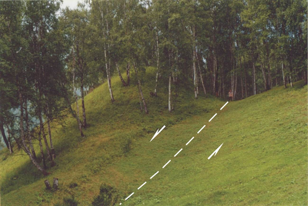
Fig. 24. Overgrown seismogenic ditch in the Main Sayan Fault zone (near the Kultuk village). Photo by V.A. Sankov (Rasskazov et al., 2010).
Рис. 24. Заросший сейсмогенный ров в зоне Главного Саянского разлома (район п. Култук). Фотография В.А. Санькова (Рассказов и др., 2010).
In the Tunka Valley, the strongest Mondy earthquake (M=7.0) occurred on April 4, 1950. Later, in 1995, there was the Zaktuy earthquake (M=5.7), and in 2003, the Khoytogol one (M=4.4). In the South Baikal Basin, strong earthquakes occurred in 1999 and 2008. In 2020, the Baikal-Khubsugul seismic reactivation began with the double Bystraya seismic event, the epicenter of which spatially corresponded to the Anchuk volcano of the Bystraya volcanic zone (Fig. 25). In June-September 2023, there was a seismic lull, after which a new seismic reactivation began with strong earthquakes in Northern Baikal and Hangay. The preparation and implementation of strong earthquakes were accompanied by effects in the earth's crust that were recorded by variations of groundwater components in the Kultuk reservoir (Rasskazov et al., 2025b).
Fig. 25. Scheme of spatial superposition of the Bystraya earthquake with the Anchuk volcano of the Bystraya volcanic zone. The relative shift of the two epicenters of the Bystraya earthquake is shown after (Map…, 2025), taking into account the direction of the Bystraya volcanic zone.
Рис. 25. Схема пространственного совмещения Быстринского землетрясения с Анчукским вулканом Быстринской вулканической зоны в восточной части Тункинской долины. Относительное смещение двух эпицентров Быстринского землетрясения показано по данным сайта (Карта…, 2025) с учетом простирания Быстринской вулканической зоны.
Monitoring station 27 of the Kultuk area is located in distance of 25 km from the epicenter of the Bystraya earthquake, in the transitional area from the stretching central part of the BRS to its compressing western part. The monitoring station actually corresponds to the geometric center of strong BRS earthquakes in 2020–2025 (Fig. 26). Its hydrogeochemical responses were rather sensitive to all seismic events of the BRS (Rasskazov et al., 2025b).
Fig. 26. Scheme of distribution of strong earthquakes in the center and west of the BRS in 2020–2025. Structural elements of the Hangay orogen are shown after (Korina, 1982). Strong earthquakes of the central part of the BRS: KU – Kudara, KHN – Khentei, BA – Babushkin, GO1,2 – Goloustnoe 1 and 2, NB – North-Baikal. Strong earthquakes of the western BRS: KHU – Khubsugul, TO – Tofalar, DA – Darkhat, CHL – Chulutyn. The earthquakes KHN, KU, BA, GO1,2, KHU, ТО and DA belong to the Baikal-Khubsugul seismic reactivation, those NB and CHL – to the North Baikal-Hangay one. The initial strong Bystraya earthquake is preceded by earthquakes of moderate strength (in the north-south direction): KY – Kyren in the Tunka Valley and MU – Murino in the South Baikal basin. The last strong Chulutyn earthquake is preceded (in the north-south direction) by the moderate Khara-Khuzhir earthquake (KHKH). It is followed by the moderate Mondy earthquake (MN). Red arrows show episodes of redistribution of strong earthquakes from the center to the west of the BRS. The catalog (Map…, 2025) is used.
Рис. 26. Схема распределения сильных землетрясений в центральной и западной частях БРС в 2020–2025 гг. Структурные элементы Хангайского орогена показаны по данным (Корина, 1982). Сильные землетрясения центра БРС: KHN – Хэнтэйское, KU – Кударинское, BA – Бабушкинское, GO1,2 – Голоустенские Первое и Второе, NB – Северо-Байкальское. Сильные землетрясения запада БРС: KHU – Хубсугульское, ТО – Тофаларское, DA – Дархатское, CHL – Чулутынское. Землетрясения KHN, KU, BA, GO1,2, KHU, ТО и DA относятся к Байкало-Хубсугульской сейсмической активизации, землетрясения NB и CHL – к Северо-Байкало-Хангайской. Начальному сильному Быстринскому землетрясению предшествуют землетрясения умеренной силы (в субширотном направлении): KY – Кыренское в Тункинской долине и MU – Муринское в Южно-Байкальской впадине. Последнему сильному Чулутынскому землетрясению предшествует (в субмеридиональном направлении) умеренное Хара-Хужирское землетрясение (KHKH), а за ним следует умеренное Мондинское землетрясение (MN). Использован каталог (Карта…, 2025).
Mudflows
A. Lvov and G. Kropachev were the first, who described mudflows in the Tunka Basin that descended along the Kyngarga River in 1897 and along the Khairok and Khurai-Khobok Rivers in 1903. On August 2, 1903, after a downpour that broke out over Tunka, large area of arable land near the Ulyabory ulus (setlment) were covered with mudflows and boulders (along the tributaries of the Kharimpta and Khurai-Khobok Rivers. The downpour terribly devastated the middle part of the basin. Two weeks later, entire lakes stood in the valley. A flood occurred in the Arshan village on June 25 and 27, 1912. In 1952, a flood on the river Kyngarga caused a rise in its level by 3 m or more. In 1962, there was a mudflow in the area of the Arshan resort on the night of July 17–18 (Makarov, 2012).
At a conference dedicated to the 20th anniversary of the Tunka National Park in the summer of 2011 in the Vyshka resort, V.K. Laperdin warned that a mudflow was prepared in the area of the Arshan resort. The mudflow of 2014 that occurred on the night of June 27–28 had serious consequences here. Later, V.K. Laperdin said: “The boulders that we managed to find and measure reached three meters in diameter. The flow moved at a speed of 5 to 10 meters per second. By the time it reached the village, the width of the flow reached 500–600 meters, and the thickness (depth) was 4.0–4.5 meters. ”The Stone River” mudflow was derived from one of the glacial cirques of the Tunka Range. Mudflow deposits on the surface of the Stone River consist of large (on average, 40–50 cm) blocks of igneous, metamorphic, and sedimentary rocks (Fig. 27a). Blocks of igneous rocks predominate, represented mainly by medium-coarse-grained granodiorite, diorite, and gabbro. In the area near the houses, cleared of debris, only the largest blocks up to 3 m in size remained. Rare large blocks of metamorphic rocks (gneisses, crystalline schists, chlorite schists, marbles) and small (up to 20 cm) blocks of pink (potassium) granites, sedimentary rocks (siltstones) and basalts were found on the surface of the Stone River. Siltstone and basalt fragments from the Stone River are compared with Cenozoic sedimentary deposits and basalts occurring in the Tunka Basin.
Fig. 27. Young geologists on the Stone River (a) and coarse clasts of sediments on the 40-meter high terrace of the Kyngarga River (b).
Рис. 27. Молодые геологи на Каменной реке (a) и крупно-обломочные отложения 40-метровой террасы р. Кынгарга (б).
Summary
Two dangerous geological processes have been displayed in the Tunka Valley: earthquakes and mudflows. Special studies are being conducted to determine the place and time of possible manifestation of these processes in the future. The time and place of future strong earthquakes in the Tunka Valley are determined by monitoring hydrogeochemical studies of groundwater. Mudflows have repeatedly occurred in the area of the Arshan village and will occur in the future.
Tectonic development of basins in the Tunka Valley and southern Lake Baikal
Sharp change in the earth's crust structure at the junction between the South Baikal Basin and Tunka Valley
The structure of the Baikal Rift System changes sharply between the South Baikal Basin and Tunka Valley. This change is reflected in the deep structure of the earth's crust and underlying mantle (Fig. 28).
When moving from the Tunka Basin through the Tory Basin to the Bystraya one and further to Lake Baikal, one observes a succession of basins filled with sedimentary rocks. This area was uplifted. As a result, sedimentary rocks were partially eroded. This indicates a change in the development of the eastern part of the Tunka Valley due to the compression of the upper crust. In the area of the Kultuk village, Quaternary reverse faults are clearly recorded. The basin of Lake Baikal was formed under conditions of extension that continues at present. From space geodesy measurements (Sankov et al., 2014), the sides of Southern Baikal diverge northwest – southeast with a rate of 3.4 ± 0.7 mm/year.
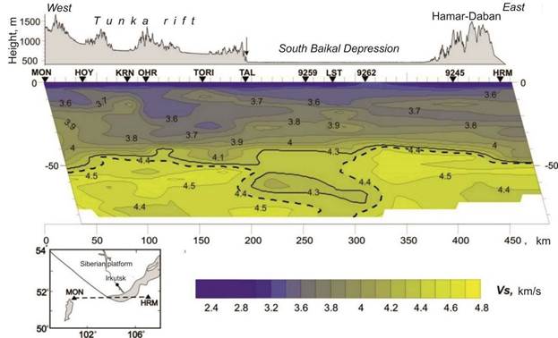
Fig. 28. VS-section along the profile of the settlement Mondy–settlement Khuramsha (Mordvinova et al., 2017). The profile line is shown in the inset.
Рис. 28. VS-разрез по профилю п. Монды–п. Хурамша (Мордвинова и др., 2017). Линия профиля показана на врезке.
Sedimentary filling of the Baikal basins
Bottom morphology of Lake Baikal shows the southern, middle, and northern basins. The middle one is separated from the southern by the alluvial fan of Selenga Delta. Such morphological division of the lake bottom means separation of water lenses, but does not make sense for the interpretation of the rift structure. From gravity modeling (Logatchev, Zorin, 1992), the southern and middle basins form a single South Baikal unit. Thickness of Cenozoic deposits of Lake Baikal is estimated to be up to 6 km. From seismic profiling (Hutchinson et al., 1992), 2 subdivisions of the layered strata (A, B) are distinguished in the sedimentary section and in the South Baikal basin – an underlying seismically transparent zone (C). The latter sedimentary unit got different interpretations. From study of sedimentary sequences on the southern shore of the South Baikal, we inferred that seismically transparent zone designates mylonites of a suture zone between the Siberian paleocontinent basement and accreted terranes (Rasskazov et al., 2021b).
Fig. 29 shows representative seismic profiles 4 and 17 of the sedimentary filling of the South Baikal Basin, spatially corresponding to the Osinovka and Mishikha-Klyuevka paleovalleys of the southern coast of Lake Baikal. Profile 4 clearly separates two layers of bottom sediments: the lower, folded one and the upper, horizontally layered one. The upper layer is shifted toward the northern side of the basin. At the southern side, horizontal layering is absent, and the bottom surface rises slightly. Such a structure of the profile that reflects the asymmetry of the Baikal-type basins suggests an intensive influx of sedimentary material into the lake mainly from its southern side. Rhythmically layered material is present in the lower parts of the bottom sediment section in both the northern and southern parts of the lake. At the top of the bottom sediment section of the southern part of the basin, the layering becomes indistinct, indicating a lateral replacement of rhythmic sediments by unlayered material of the Osinovka paleovalley delta. After the folded deformations, the same unlayered material continued to accumulate in the southern part of the basin simultaneously with the accumulation of deep-water sediments in its northern part. Unlike profile 4, on profile 17, horizontally layered sediments are not individualized in the uppermost part of the section. The bottom of the lake is deformed by faults with vertical displacement. Weak layering is visible only near the northwestern shore, in the area of the Posolskaya Bank. In the bottom sediments, unsorted material of the Mishikha-Klyuevka paleovalley seems to predominate.
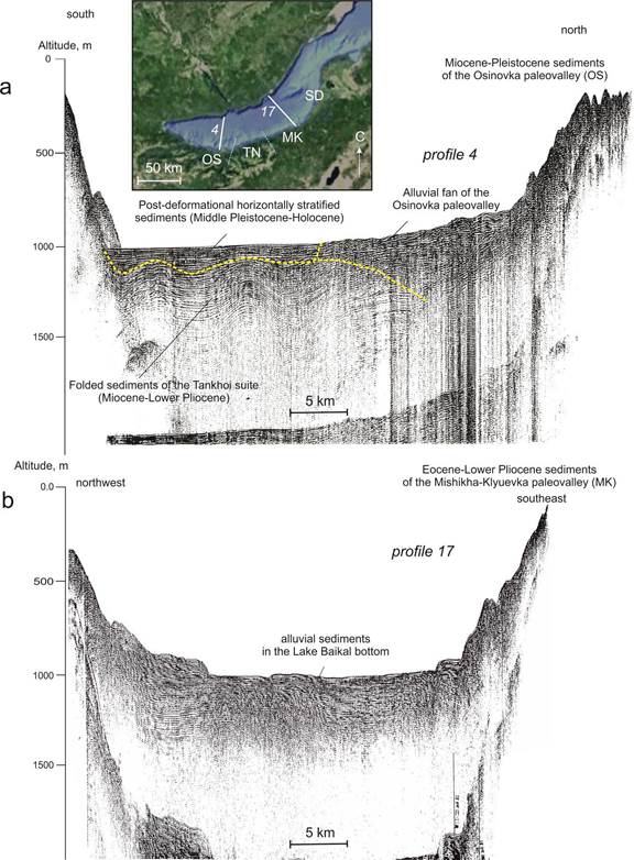
Fig. 29. North-south (а) and northwest-southeast (b) seismic profiles across Lake Baikal. Adopted after (Levi et al., 1997). The profile locations are shown in the inset. On the southern shore of Lake Baikal, profiles 4 and 17 spatially correspond to alluvial deposits of the Osinovka (OS) and Mishikha-Klyuevka (MK) paleovalleys, separated by the Tankhoi block (TN) with swamp-oxbow deposits. The stratigraphic units of the Mishikha-Klyuevka paleovalley and Tankhoi block correlate with those of Selenga Delta (SD).
Рис. 29. Сейсмические профили через озеро Байкал: субмеридиональный (а) и северо-западный (б). Основа из работы (Levi et al., 1997). Местоположение профилей показано на врезке. На южном берегу Байкала профилям 4 и 17 пространственно соответствует распространение аллювиальных отложений Осиновской (ОS) и Мишихинско-Клюевской (MK) палеодолин, разделенных Танхойским блоком (TN) с болотно-старичными отложениями. Стратоны разреза отложений Мишихинско-Клюевской палеодолины и Танхойского блока коррелируются со стратонами разреза, вскрытого скважинами в дельте р. Селенга (SD).
Relationship between old lakes of the Tunka Valley and Paleo-Baikal
Clastic debris seems to accumulate in the basins of the Tunka Valley rather quickly. The mudflow of the Stone River of 2014 showed a pattern of such a quick modern destruction of the Tunka Ridge by an avalanche movement of debris from the ridge into the basin (Rasskazov et al., 2023).
The South-West Border Fault of the South Baikal Basin extends along the zone of granulite metamorphism of the Slyudyanka sub-terrane. This fault is in discordant relations with the Tankhoi tectonic step that was separated by faults from both the uplifted Khamar-Daban Ridge and the subsided lake bottom. The Obruchev fault separates part of the Siberian paleocontinent's basement from its base (Fig. 30).
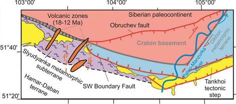
Fig. 30. Scheme of control of the Pra-Anosovka source of the Paleo-Manzurka by the edge of the cratonic basement of the Siberian paleocontinent. A fragment of the Slyudyanka metamorphic sub-terrane is shown after (Shafeev, 1970).
Рис. 30. Схема контроля пра-аносовского истока Пра-Манзурки краем кратонного фундамента Сибирского палеоконтинента. Фрагмент Слюдянского метаморфического субтеррейна показан по работе (Шафеев, 1970).
The boundary between the subsided triangle of the cratonic basement and the Olkhon metamorphic terrane is traced by earthquakes (Rasskazov et al., 2020, 2021a). In the southwestern part of the South Baikal Basin, there are signs of inversion of the crustal extensional forces to compressional ones, expressed in the formation of folds of the bottom sediments of Lake Baikal at this boundary. Compression at the Miocene-Pliocene boundary is also reflected in the overturning Eocene-Lower Pliocene sediments in the Mishikha section of the Tankhoy tectonic step (Al Hamud et al., 2021). Pra-Anosovka was part of the system of Miocene-Pliocene watercourse that extended from Pra-Anosovka (southern cost of the future Lake Baikal) to Pra-Manzurka (its northern coast) along the edge of the Siberian paleocontinent basement that was involved in right-lateral transtension with the displacement of the lowered block of the Baikal bed relative to the Olkhon metamorphic terrane. The spread of transtension along the Primorsky suture of the Siberian paleocontinent contributed to the creation of a right-lateral system of echelon-like segments and the formation of the Pra-Manzurka valley at the beginning of the Pliocene, about 5–4 million years ago.
History of river runoff from Lake Baikal in the last 2 Ma
Physical geography operates with the law: only one river can flow out of a lake. In the last 2 Ma, waters of Lake Baikal has flowed: 1) through the valleys of the Kultuchnaya River and Ilcha River into the Irkut River and further along the Angara River into the Yenisei River, 2) through the Paleo-Manzurka River valley into the Lena River valley, and 3) through the Angara River into the Yenisei River (Kononov, 2005) (Fig. 31).
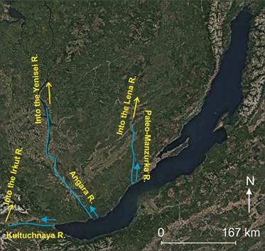
Fig. 31. Directions of river flows from Lake Baikal in the last 2 Ma.
Рис. 31. Направления речного стока из оз. Байкал в последние 2 млн лет.
Summary
In the transition from the Tunka Valley to Lake Baikal, structure of the earth's crust and underlying mantle changes dramatically. Basins of Lake Baikal were filled with sedimentary deposits and water, unlike those of the Tunka Valley filled with sedimentary deposits alternating with volcanic rocks. During the development of the eastern part of the Tunka Valley, there was an inversion of tectonic motions occurred due to the change in crustal extension to compression, although in the South Baikal Basin the crust was stretched and continues stretching at present. The different nature of the development of the South Baikal Basin and Tunka Valley resulted in the change in the direction of river flow from Lake Baikal to the Yenisei River, Lena River, and then back to the Yenisei River.
Conclusion
To present comprehensive introduction into rifting processes, we defined their place in the Tunka Valley occurred in the late Cenozoic relative tectonic unites of pre-Cenozoic basement, described tectonic features of the valley, designated stratigraphic sequence of sedimentary and volcanic rocks in basins, showed the latest seismic interpretations of deep structure of the crust and the underlying mantle, discussed specific information on groundwaters, and characterized recent displaying of dangerous phenomena such as earthquakes and mudflows.
The axial structures of the young (Cenozoic) Baikal Rift System obviously inherited the structure of the pre-Cenozoic basement. There is a junction between the South Baikal Basin and Tunka Valley in the Kultuk village area. The earth's crust of the former has been stretched for a long time and continues to stretch at present, while the eastern part of the latter was affected by hot transtension from 18 to 12 Ma and then was compressed. The transition from compression to extension at 13–12 Ma is established through dating of volcanic rocks.
The Tunka Valley is a chain of basins, the largest of which (Tunka) is located in its central part. This basin was affected by extension more than other basins of the valley. The Tunka Basin accumulated a volcanogenic-sedimentary layer of maximum thickness (up to 2.5 km). Volcanic activity began here about 16 Ma ago and finalized at 0.9-0.8 Ma ago. The mineral springs of this area have hydrogeochemical parameters indicating their connection with deep sources of crust-mantle transition (high 3He/4He ratio and 234U/238U activity ratio close to 1). High permeability of the Tunka Basin crust for fluids might result into its permeability for magmatic melts. A future volcanic eruption in the Kyngarga fault seems to be quite real.
Earthquakes and mudflows were considered as dangerous geological processes. Earthquakes reactivated in the Baikal area since 2020 and currently studied through hydrogeochemical monitoring of groundwaters. In 2014, a mudflow covered the Arshan resort area. Such phenomena are common in mountainous terrains. Apparently, processes like these caused the accumulation of coarse-grained Anosovka suite in basins of the Baikal Rift System in the past 5–3 years.
The Tunka Valley, initially chosen by N.A. Florensov as the reference tectonic structure of the Baikal Rift Zone, nowadays preserves its value for solving the main problems related to rifting processes in the continental lithosphere. The presented data on the Tunka Valley is only a short introduction into rifting problems that were discussed on this area in many published papers.
Future Work in the Tunka Valley and South Baikal Basin
1) comparative study of sedimentation in basins,
2) study of pseudotachylytes in suture zones between major tectonic units,
3) study of volcanic rocks and deep-seated inclusions from them for deciphering structure and development of the lithosphere,
4) study of deep groundwater components, monitoring their temporal variations for earthquake prediction,
5) study of dangerous geological processes, such as earthquakes and mudflows.
Referencies
Ailow Yu., Rasskazov S.V., Chuvashova I.S., Yasnygina T.A. Olivine as an indicator of polygenetic association of inclusions in late Cenozoic volcanic rocks of the Tunka Valley, Baikal rift zone // Lithosphere. 2021a. Vol. 21, No. 4. P. 517–545.
Ailow Yu., Rasskazov S.V., Yasnygina T.A., Chuvashova I.S. Finding of Fe–Si inclusions in deep-seated nodules from trachybasalts of the Karyerny volcano (Tunka Valley of the Baikal Rift System) and its significance for understanding the origin of ferruginous quartzites of the Great Oxidation Event // XIII All-Russian Petrographic Conference (with the participation of foreign scientists) “Petrology and Geodynamics of Geological Processes”. September 6–13. Irkutsk: IGC SB RAS and IEC SB RAS. 2021b. P. 18–23.
Al Hamoud A., Rasskazov S.V., Chuvashova I.S., Tregub T.F., Rubtsova M.N., Kolomiyets V.L., Budaev R.Ts., Hassan A., Volkov М.А., 2021. Overturned Eocene – Lower Pliocene alluvial stratum on the southern coast of Lake Baikal and its neotectonic significance // Geodynamics & Tectonophysics 12 (1), 139–156. doi:10.5800/GT-2021-12-1-0518.
Barash I.G., Salnikova E.B., Reznitsky L.Z. et al. Age relationships of metamorphism of the Slyudyanka granulite and Hamar-Daban zonal metamorphic complexes: results of U–Pb geochronological studies // Reports of the Academy of Sciences. 2006. Vol. 409. No. 3. P. 381–385.
Belichenko V.G., Gelety N.K., Barash I.G. Barguzin microcontinent (Baikal mountain region): on the problem of identification // Geology and Geophysics. 2006a. Vol. 47, No. 10. P. 1049–1059.
Belichenko V.G., Reznitsky L.Z., Makrygina V.A., Barash I.G. Terranes of the Baikal-Khubsugul fragment of the Central Asian mobile belt of paleosides. State of the problem // Geodynamic evolution of the lithosphere of the Central Asian mobile belt (from ocean to continent): Proceedings of the meeting. Irkutsk: IZK SB RAS. 2006b. Vol. 1. P. 37–40.
Bindeman I.N., Bekker A., Zakharov D.O. Oxygen isotope perspective on crustal evolution on early Earth: Arecord of Precambrian shales with emphasis on Paleoproterozoic glaciations and Great Oxygenation Event // Earth and Planetary Science Letters. 2016. V. 437. P. 101–113.
Chuvashova I.S., Rasskazov S.V., Saranina E.V. 207Pb–206Pb age of sources of Late Cenozoic volcanic rocks of the crust-mantle transition in relation to the age of ophiolites and ancient blocks exposed on the surface of the crust: transect Kitoi–Baydrag of the Baikal-Mongolian region // Geology and Environment. 2022. Vol. 2, No. 2. P. 61–90. DOI 10.26516/2541-9641.2022.2.61
Dril' S.I., Chukanova V.S., Dubinina E.O., Sandimirov I.V., Vladimirova T.A., Sklyarova O.A., Ikonnikova T.A. Isotope Sr-O-H-U systematics and genesis of surface and mineral waters of the Tunka Basin of the Baikal Rift System // Problems of geochemistry of endogenous processes and the environment. Conference materials. Irkutsk: Publishing House of the V.B. Sochava Institute of Geography SB RAS, 2007. Vol. 1. P. 158–162.
Eguchi J., Seales J., Dasgupta R. Great Oxidation and Lomagundi events linked by deep cycling and enhanced degassing of carbon // Nature Geoscience. 2020. V. 13. P. 71–76.
Fundamentals of hydrogeology. General hydrogeology. Novosibirsk: Nauka, 1980. 225 p.
Galaziy G.I. The Baikal in questions and answers. Irkutsk: East Siberian Book Publishing House, 1984. 267 p.
Gao R., Hou H., Cai X., Knapp J.H., He R., Liu J., Xiong X., Guan Y., Li W., Zeng L., Roecker S.W. Fine crustal structure beneath the junction of the southwest Tian Shan and Tarim Basin, NW China // Comparative evolution of past and present accretionary orogens: Central Asia and the circum-Pacific / R. Hall, B.-M. Jahn, J.Wakabayashi, W. Xiao (eds.). Lithosphere GSA Data Repository Item 2013224. Geological Society of America, 2013. doi: 10.1130/L248.1
Geological excursions / Problems of rifting (Proceedings for the symposium on the rift zones of the Earth). Eds N.A. Florensov and N.A. Logatchev. Irkutsk: East Siberian branch, 1975. P. 123–149.
Grudinin M.I., Chuvashova I.S. (Eds) Baikal. Geology. Human being. Irkutsk State University Publishers, 2011. 239 p.
Grudinin M.I., Rasskazov S.V., Kovalenko S.N., Ilyasova A.M. Early Paleozoic gabbro-syenite Snezhinsky massif of the southwestern Baikal region // Geology and Geophysics. 2004. Vol. 45. No. 9. P. 1092–1101.
Ivanenko V.V., Karpenko M.I., Lizarev M.A. Age of Slyudyanka phlogopite deposits // Bulletin of the Academy of Sciences. Geol. Series. 1990. No. 5. P. 92–98.
Hutchinson D.R., Golmshtok A.J., Zonenshain L.P., Moore T.C., Scholz C.A., Klitgord K.D. Depositional and tectonic frame work of the rift basin of Lake Baikal from multichannel seismic data // Geology. 1992. V. 20. P. 589–592.
Khain E.V., Neimark L.A., Amelin Yu.V. Caledonian stage of remobilization of the Precambrian basement of the Gargan block, Eastern Sayan (isotope-geochronological data) // Reports of the Russian Academy of Sciences. 1995. Vol. 342, No. 6. P. 776–780.
Kiseleva O.N., Airiyants E.V., Dmitriy K. Belyanin D.K., Zhmodik S.M., Ashchepkov I.V., Kovalev S.A. Multistage magmatism in ophiolites and associated metavolcanites of the Ulan-Sar’dag mélange (East Sayan, Russia) // Minerals. 2020. V. 10. P. 1077.
Kononov E.E. Baikal. Aspects of paleogeographic history. Irkutsk, 2005. 128 p.
Kotov A.B., Salnikova E.B., Reznitsky L.Z., Vasiliev E.P., Kazakov I.K., Yakovleva S.Z., Kovach V.P., Berezhnaya N.G. On the age of metamorphism of the Slyudyansky crystalline complex (Southern Baikal region): results of U-Pb geochronological studies of granitoids // Petrology. 1997. Vol. 5. No. 4. P. 227–239.
Kovach V., Salnikova E., Wang K. L. et al. Zircon ages and Hf isotopic constraints on sources of clastic metasediments of the Slyudyansky high grade complex, southeastern Sibe ria: implication for continental growth and evolution of the Central Asian Orogenic Belt // J. Asian Earth Sci. 2013. Vol. 62. P. 18–36.
Kusky T.M., Polat A., Windley B.F., Burke K.C., Dewey J.F., Kidd W.S.F., Maruyama S., Wang J.P., Deng H., Wang Z.S., Wang C., Fu D., Li X.W., Peng H.T. Insights into the tectonic evolution of the North China Craton through comparative tectonic analysis: a record of outward growth of Precambrian continents // Earth Sci. Rev. 2016. V. 162. P. 387–432. https://doi.org/10.1016/j.earscirev.2016.09.002.
Kustov Yu.I., Pinneker E.V., Songolov V.I., Murashova T.V., Sizykh T.P. Carbonated mineral waters of the Arshan-Tunkinsky resort and the state of its hydromineral resources // Siberian Medical Journal. 2002. No. 6. P. 35–42.
Lekhatinov A.M., Lekhatinova E.B. Objects of environmental monitoring and educational tourism of the Tunka National Park. Irkutsk: Publishing house of OOO Reprocenter A1, 2008. 224 p.
Levi K.G., Miroshnichenko A.I., San'kov V.A., Babushkin S.M., Larkin G.V., Badardinov A.A., Wong H.K., Coleman S.& Delvaux, D. Active faults of the Baikal basin // Bull. Centre rech. Elf explor. Prod. 1997. Vol. 21, No. 2. P. 399–434.
Levitsky V.I., Levitsky I.V., Rasskazov S.V., Ailow Yu., Chuvashova I.S., Yasnygina T.A., Saranina E.V. Guide to the South Baikal excursion "Rocks of the south of Eastern Siberia". XIII All-Russian petrographic conference (with the participation of foreign scientists). Petrology and geodynamics of geological processes. A.P. Vinogradov Institute of Geochemistry SB RAS, Irkutsk, 2021. 101 p.
Li Z.W., Roecker S., Li Z.H., Wei B., Wang H., Schelochkov G., Bragin V. Tomographic image of the crust and upper mantle beneath the western Tien Shan from the MANAS broadband deployment: Possible evidence for lithospheric delamination // Tectonophysics. 2009. V. 477 (1-2). P. 49–57.
Logatchev N.A. Cenozoic continental deposits of the Baikal-type basins // Bulletin of the USSR Academy of Sciences. Geological Series. 1958. No. 4. P. 18–29.
Logatchev N.A. Sayan-Baikal and Stanovoy Uplands // Uplands of the Baikal and Transbaikal regions. Moscow: Nauka. 1974. P. 7–163.
Logatchev N.A. Volcanogenic and sedimentary formations of rift zones of East Africa. Moscow: Nauka, 1977. 183 p.
Logatchev N.A. (ed.) Guidebook for excursion on South of East Siberia. The 27th International Geological Congress, USSR, Moscow, 1984. 168 p.
Logatchev N.A. (ed.) The Middle and Southern Baikal and the Tunka basin. Guidebook. Irkutsk: Institute of the Earth’s crust SB RAS, 1987. 17 p.
Logatchev N.A. History and geodynamics of lake Baikal rift in the context of the Eastern Siberia rift system: a review // Bull. Centr. Explor. Prod. Elf Aquitaine. 1993. Vol. 17, No. 2. P. 353–370.
Logatchev N.A., Zorin Yu.A. Baikal rift zone: structure and geodynamics // Tectonophysics. 1992. Vol. 208. P. 273–286.
Logatchev N.A., Adamenko O.M., Aksenov M.P., Bazarov D.B., Belova V.A., Vorob’eva G.A., Galkin V.I., Goldyrev G.S., Endrichinsky A.S., Erbaeva M.A., Kononov E.E., Kravchinsky A.Ya., Kulagina N.V., Mats V.D., Medvedev G.I., Orlova L.A., Osadchy S.S., Panychev V.A., Pleshanov S.P., Pokatilov A.G., Popova S.M., Rasskazov S.V., Pomazina A.A., Savel’ev N.A., Svinin V.V., Sizikov A.M., Firsov L.V., Shimaraeva M.K. XI Congress INQUA guidebook of excursions A–13 and C–13. Moscow, 1981. 43 p.
Makarov S. Mudflows of the Baikal region. Irkutsk: Publishing house of the V.B. Sochava Institute of Geography SB RAS, 2012. 98 p. [Макаров С. Сели Прибайкалья. Иркутск: Изд-во института географии им. В.Б. Сочавы СО РАН, 2012. 98 с.].
Map of earthquake epicenters. Irkutsk: Baikal Branch of the Federal Research Center Unified Geophysical Service of the Russian Academy of Sciences, 2025. http://www.seis-bykl.ru
Mazilov V.N., Kashik S.A., Lomonosova T.K. Oligocene deposits of the Tunka Basin (Baikal rift zone) // Geology and Geophysics. 1993. Vol. 34, No. 8. P. 81–88.
Melnikov A.I. Structural evolution of metamorphic complexes of old shields. Novosibirsk: Academic Publishing House "Geo", 2011. 288 p.
Milanovsky E.E. Rift zones of the continents. Moscow: Nedra, 1976. 279 p.
Milanovsky E.E. Riftogenesis and its role in the development of the Earth // Soros educational journal. 1999. No. 8. P. 60–70.
Mordvinova V.V., Kobelev M.M., Khritova M.A., Kobeleva E.A., Trynkova D.S. Velocity structure of the southern margin of the Siberian craton and its folded surroundings based on body waves of distant earthquakes // Inter Expo GEO-Siberia. 2017. Vol. 4, No. 1. P. 37–41.
Olsen K.H., Morgan P. Introduction: Progress in understanding continental rifts // Continental rifts: Evolution, structure, tectonics / K.H. Olsen (Ed.) Publication No. 264 of the International Lithosphere Program. Elsevier: Amsterdam–Lausanne–New York–Oxford–Shannon–Tokyo, 1995. P. 3–26.
Pavlov S.Kh., Chudnenko K.V., Golubev V.A., Orgilyanov A.I., Badminov P.S., Kryukova I.G. Geological factors and physicochemical processes of formation of groundwater in the Tunka Basin // Geodynamics and Tectonophysics. 2018. Vol. 9, No. 1. P. 221–248.
Pinneker E.V., Pisarsky B.I., Lomonosov I.S., Koldysheva R.Ya., Didenko A.A., Sherman S.I. Hydrogeology of the Baikal region. Moscow: Nauka publishing house, 1968. 170 p.
Polyak B.G. Helium isotopes in the ground fluids of the Baikal Rift and its surroundings: Contribution to continental rifting geodynamics // Russian Journal of Earth Sciences. 2003. Vol. 5, No 1. P. 45–66.
Povyshev A.S. Final consolidated report on the Tunka reference well No. 2-O. Part 1. Irkutsk, 1956. 127 p.
Rasskazov S.V. Magmatism of the Baikal Rift System. Novosibirsk: Nauka. Siberian Publishing Company, 1993. 288 p.
Rasskazov S.V. Volcanism and structure of the northeastern Baikal Rift System // Geology and Geophysics. 1996. Vol. 37. No. 4. P. 60–70.
Rasskazov S.V. Brandt S.B., Brandt I.S. Radiogenic isotopes in geologic processes. Springer, 2010. 306 p.
Rasskazov S.V., Chebykin E.P., Chuvashova I.S., Ilyasova A.M., Snopkov S.V., Sun Yi-min Monitoring of uranium components and Si – Na/Li temperatures in the Arshan groundwater reservoir of Tunka Valley in 2012–2024: Tracing paragenetic relationships between hydrogeochemical and seismic processes in the Baikal Rift System // Geology and Environment. 2024. Vol. 4, No. 3. P. 65–112. https://doi.org/10.26516/2541-9641.2024.3.65
Rasskazov S.V., Chebykin E.P., Ilyasova A.M., Snopkov S.V., Chuvashova I.S. Expanding seismicity and paragenetic variations of groundwater compositions in the Baikal Rift System in 2020–2025: Current state assessment of the earth's crust // Geology and Environment. 2025b. Vol. 5, No. 2.
Rasskazov S., Chuvashova I., Yasnygina T., Saranina E., Gerasimov N., Ailow Y., Sun Y.-M. Tectonic generation of pseudotachylytes and volcanic rocks: Deep-seated magma sources of crust-mantle transition in the Baikal Rift System, Southern Siberia // Minerals. 2021a. Vol. 11, No. 5. P. 487.
Rasskazov S.V., Grudinin M.I., Snopkov S.V., Chuvashova I.S. Volcanism, sedimentation and tectonics of the Tunka Valley – excursion objects for geologists, students and schoolchildren // Extended abstracts of the report in the collection: Nature conservation activities in modern society. Proceedings of the International scientific and practical conference “Tunka National Park – 20 years; nature conservation activities in modern society”. Irkutsk: Publishing House of the V.B. Sochava Institute of Geography SB RAS, 2011. P. 76–78.
Rasskazov S., Ilyasova A., Bornyakov S., Chuvashova I., Chebykin E. Responses of a 234U/238U activity ratio in groundwater to earthquakes in the South Baikal Basin, Siberia // Front. Earth Sci. 2020. V. 14 (4): 711–737; doi.org/10.1007/s11707-020-0821-5
Rasskazov S.V., Ilyasova A.M., Chebykin E.P., Gutareva O.S., Snopkov S.V. PresentDay involvement in deformations of the Siberian Paleocontinent margin in the Baikal Rift System: evidence from U-H-O-isotope systematics of groundwater // Geology and Environment. 2025a. Vol. 5, No. 1. P. 129- 158. DOI 10.26516/2541-9641.2025.1.129
Rasskazov S.V., Kolomiets V.L., Budaev R.Ts., Chuvashova I.S., Al-Hamud A., Hassan A., Alokla R. Recent reactivation of the Siberian craton suture zone beneath the Southern Baikal: from Cretaceous-Paleogene orogen to Neogene-Quaternary rift // Geology and Environment. 2021b. Vol. 1, No. 1. P. 7–15. https://doi.org/10.26516/2541-9641.2021.1.7.
Rasskazov S.V., Luhr J.F., Bowring S.A., Ivanov A.V., Brandt I.S., Brandt S.B., Demonterova E.I., Boven A.A., Kunk M., Housh T., Dungan M.A. Late Cenozoic volcanism in the Baikal rift system: evidence for the formation of the Baikal and Khubsugul basins due to thermal impacts on the lithosphere and collision-derived tectonic stress // Berliner palaobilogische abhandlungen. 2003. Vol. 4. P. 33–48.
Rasskazov S.V., Reshetova S.A., Yasnygina T.A., Chuvashova I.S., Saranina E.V., Rubtsova M.N., Al Hamud A., Hassan A. Upper Miocene-Pliocene sediments of Pra-Anosovka as a source of Pra-Manzurka alluvium: Pre-Baikal transport of detrital material through the South Baikal depression // Geology and Environment. 2023. Vol. 3, No. 4. P. 82–107. https://doi.org/10.26516/2541-9641.2023.4.82
Rasskazov S.V., Sankov V.A., Ruzhich V.V., Smekalin O.P. Cenozoic continental rifting: A guide to geological excursion to the Tunka rift valley / Institute of the Earth's crust SB RAS, Irkutsk, 2010. 40 p.
Rasskazov S.V., Yasnygina T.A., Chuvashova I.S., Mikheeva E.A., Snopkov S.V. The Kultuk Volcano: spatial–temporal change of magmatic sources at the western terminus of the South Baikal basin between 18 and 12 Ma // Geodynamics & Tectonophysics. 2013. Vol. 4, No. 2. P. 135–168. doi:10.5800/GT-2013-4-2-0095.
Reznitsky L.Z., Fefilov N.N., Vasiliev E.P., Zarudneva N.V., Nekrasova E.A. Lead isotope compositions of metaphosphorites and the problem of the age of the Slyudyanka series (Southern Baikal region - Western Hamar-Daban) // Lithology and mineral resources. 1998. No. 5. P. 484–493.
Sankov V.A., Lukhnev A.V., Miroshnichenko A.I., Dobrynin A.A., Ashurkov S.V., Byzov L.M., Dembelov M.G., Calais E., Deversher J. Modern horizontal movement and seismic activity south of the Baikal basin (Baikal Rift System) // Physics of the Earth. 2014. Vol. 6. P. 70–79.
Savelyeva V.B., Presnyakov S.L., Lepekhina E.N., Larionov A.N., Bazarova E.P. Main stages of granite and pegmatite formation in the southeastern part of the Main Sayan Fault, Eastern Siberia (based on U-Pb zircon dating, SHRIMP-II) // Reports of the Academy of Sciences. 2012. Vol. 442. No. 3. P. 369–375.
Sal’nikova E.B., Sergeev S.A., Kotov A.B., Yakovleva S.Z., Steiger R.H., Reznitskiy L.Z., Vasil’ev E.P. U–Pb zircon dating of granulite metamorphism in the Sludyanskiy complex, Eastern Siberia. // Gondwana Research. 1998. Vol. 1. No. 2. P. 195–205.
Shafeev A.A. Precambrian of the South-West Baikal Region and Khamar-Daban. Moscow: Nauka, 1970. 177 p.
Shkolnik S.I., Stanevich A.M., Reznitskiy L.Z., Savelyeva V.B. New data on the structure and time range of formation of the Hamar-Daban terrane: evidence from U–Pb LA–ICP–MS zircon dating // Stratigraphy. Geological correlation. 2016. Vol. 24. No. 1. P. 23–43. doi:10.7868/S0869592X15060095.
Votintsev K.K. Hydrochemistry of Lake Baikal. Proceedings of the Baikal Limnological Station, USSR Academy of Sciences, Vol. 20. 1961. 311 p. (in Russian)
Windley B.F., Kusky T., Polat A. Onset of plate tectonics by the Eoarchean // Precambrian Research. 2021. V. 352. P. 105980
Yanshin, A.L. What are rifts? // Problems of riftogenesis. Proceedings for the symposium on the rift zones of the Earth. Irkutsk: East Siberian branch, 1975. P. 5–6.
Yokota K., Kanzaki Y., Murakami T. Weathering model for the quantification of atmospheric oxygen evolution during the Paleoproterozoic // Geochimica et Cosmochimica Acta. 2013. V. 117. P. 332–347.
Zamana L.V. Deuterium and oxygen-18 waters of nitrogen thermal springs of the Baunt group (Baikal rift zone) // Bulletin of the Buryat State University. 2011. No. 3. P. 87–90.
Rasskazov Sergei Vasilevich,
doctor of geological and mineralogical sciences, professor,
664025, Irkutsk, st. Lenina, 3,
Irkutsk State University, Faculty of Geology,
Head of Dynamic Geology Char,
664033 Irkutsk, st. Lermontova, 128,
Institute of the Earth's Crust SB RAS,
Head of the Laboratory for Isotopic and Geochronological Studies,
tel.: (3952) 51–16–59,
email: rassk@crust.irk.ru
Chuvashova Irina Sergeevna,
candidate of geological and mineralogical sciences,
664033, Irkutsk, st. Lermontova, 128,
Institute of the Earth's Crust SB RAS,
Senior Researcher,
tel.: (3952) 51–16–59,
email: chuvashova@crust.irk.ru
Snopkov Sergei Viktorovich,
Candidate of Geological and Mineralogical Sciences,
664025, Irkutsk, Lenin st., 3,
Irkutsk State University, Faculty of Geology,
Associate Professor,
664074, Irkutsk, Kurchatov st., 3,
Siberian School of Geosciences, Irkutsk National Research Technical University,
Leading Researcher,
email: snopkov_serg@mail.ru
|
|
Article received: 01.08.2025; corrected: 04.08.2025; accepted: 15.08.2025.
FOR CITATION: Rasskazov S.V., Chuvashova I.S., Snopkov S.V. The Tunka Valley and South Baikal Basin of the Baikal Rift System: introduction into rifting processes in the continental lithosphere // Geology and Environment. 2025. Vol. 5, No. 3. P. 7–53. DOI 10.26516/2541-9641.2025.3.7. EDN: ZZPYHC