https://doi.org/10.26516/2541-9641.2025.3.54
Geology of the Western Coast of Lake Baikal in the Vicinity of the Bolshaya and Malaya Kadilnaya Valleys *
S.N. Kovalenko
Irkutsk State University, Irkutsk, Russia
Abstract. The article provides a geological description of the western shore of Lake Baikal in the area, where stromatolite limestones of the Middle-Upper Riphean (?) formation (Baikal series) occurs. Described other geological units are Precambrian (Shumikhinsky complex of moderately alkaline granites and diorites and Zhidoi formation of the Sharyzhalgai series), Middle Jurassic continental alluvial deposits, and Quaternary lacustrine-proluvial and slope formations.
Keywords: Baikal, geology, stromatolites, Precambrian metamorphic and plutonic complexes, Riphean carbonate deposits, Jurassic conglomerates
Introduction
Along the western shore of Lake Baikal, in the area of the Bolshie Koty village, Bolshaya and Malaya Kadilnaya in easy accessibility, structural, igneous and metamorphic formations of the Early Precambrian (Shumikhinsky complex of moderately alkaline granites and diorites and the Zhidoi formation of the Sharyzhalgai series of the Archean), as well as the Middle Jurassic continental alluvial deposits of the Baikal mountain facies, lacustrine-proluvial and slope formations of modern can be studied literally in one route. The complex of these formations gives a complete understending both the geology of the Southern Baikal region and Siberian platform — its crystalline basement and sedimentary cover.
The administrative center of the research area is the Bolshiye Koty village that is situated in a vast valley of rivers with the same name – Bolshie Koty and Malye Koty Rivers (Fig. 1). In summer time, a hydrofoil vessel (Voskhod type) goes to it from Irkutsk, and in winter, a temporary automobile route runs along the ice of the lake. The beginning of the route is located along this trail at another 12 km on Bolshoi Kadilny Cape. Its length in one direction is about 4 km.
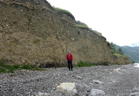
Fig. 1. Waterway to the beginning of the route from Cape Bolshoi Kadilny to Cape Malyi Kadilny.
Рис. 1. Водный путь к началу маршрута с мыса Бол. Кадильный до м. Мал. Кадильный.
The proposed route along the western coast of Lake Baikal at the interval between the mouths of the Chernaya and Malaya Kadilnaya rivers, in the vicinity of the Bolshie Koty village and Bolshoi and Malyi Kadilnyi capes of mountain-taiga has no roads except the one on the ice of Lake Baikal in winter time.
In the northern part of the territory, there is the Primorsky Range that begins from the Angara River output at an altitude of 850–950 m and stretches to the northeast, gradually rising to 1050–1130 m and acquiring an alpine character. It is the western shoulder of the South Baikal Depression. The highest altitude is represented by the Three-Headed Char with a height of 1178.2 m (Chechet, 2025). Most of the ridge is located within the National Park "Reserved Baikal Region".
The territory is seismic, earthquakes of 9-10 points are possible.
The main geological units of the route along the western coast of Lake Baikal in the vicinity of the Bolshaya and Malaya Kadilnaya river valleys can be seen in Figs 2 and 3.
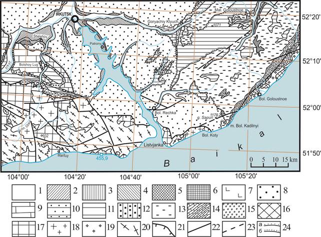
Fig. 2. Overview geological scheme of the study area.
1–6 – Quaternary formations. 1 – modern link (alluvium of river beds; lacustrine, marsh, proluvial deposits – sands, pebbles, loams, clays, boulders); 2 – Upper Quaternary link (alluvium of the first terrace above the floodplain (8–12 m); proluvial-deluvial and solifluction deposits — sands, pebbles, sandy loams, loams, gravelly-clayey formations); 3 – middle-upper Quaternary links (alluvium of the second terrace above the floodplain (12–16 m); lacustrine, water-glacial and glacial deposits – clays, loams, sandy loams, sands, pebbles, boulders, silts); 4 – Middle Quaternary link (alluvium of the third (16–20 m) and fourth (20–32 m) terraces; lacustrine, water-glacial and glacial deposits — sands, pebbles, clays, loams, sandy loams, gravel, block-gravel-clay formations); 5 – Lower Quaternary link (alluvium of the fifth (35–45 m) terrace – loams, sands, gravel, sandy loams, clays, pebbles, boulders); 6 – Upper Pliocene – Lower Quaternary link (alluvial and deluvial-alluvial deposits – sands, sandy loams, pebbles, boulders, clastic material (brightly colored, shabby); at the base – a zone of weathered bedrocks); 7 – Neogene basalts; 8 – Middle Jurassic continental deposits – sandstones, siltstones, mudstones, conglomerates, coals; 9 – Lower Cambrian marine and lagoon deposits (Usolye and Belaya formations) – dolomites, limestones, anhydrites, rock salt layers, marls, carbonate breccias, gypsums, flint lenses; 10 – Vendian-Cambrian marine deposits (Irkutsk Formation – dolomites, marls, limestones, siltstones, mudstones, sandstones, carbonate breccias, Ayana Formation – clayey dolomites, siltstones, limestones); 11–12 – Vendian marine deposits: 11 – Shaman Formation – sandstones, siltstones, argillaceous dolomites, gravelites, conglomerates, Khuzhir Formation – sandstones, gravelites, conglomerates, Kurtun Formation – sandstones, siltstones, dolomites, Ushakovskaya Formation Upper Subformation – polymictic sandstones, siltstones, argillaceous shales, conglomerates, lower subformation – conglomerates, gravelites, polymictic sandstones, siltstones, greywackes; 12 – Olkhinskaya Formation – siltstones, mudstones, siliceous-carbonate rocks, dolomites, sandstones, at the base of breccia; 13–15 – Upper Proterozoic marine formations of the Baikal series: 13 – Kachergat Formation – argillaceous, argillaceous-aleuritic and aspic shales, quartz and feldspar-quartz sandstones, conglomerates, gravelites, marly limestones, 14 – Uluntuy Formation – clayey, silticeous, carbonaceous-argillaceous shales, mudstones, sandstones, gravelites, oncolite and stromatolite limestones, phosphorites; 15 – Goloustnaya Formation – quartz and feldspar-quartz sandstones, conglomerates, gravelites, sandy-argillaceous schists, siltstones, dolomites and limestones with oncolites and stromatolites; 16 – Lower Proterozoic formations of the Olkhon series, undissected — gneisses, plagiogneisses, schists of various compositions, amphibolites, quartzites; 17 – Archean Sharyzhalgai series undissected – biotite gneisses, amphiboles, crystal schists, amphibolites, migmatites; 18–19 – Early Proterozoic intrusions: 18 – Shumikhinsky moderately alkaline intrusive-dike complex – protoclastic, plagiomicrocline, leucocratic granites and porphyritic biotite and biotite-hornblende granodiorites, less often gneisogranites, granosyenites, pegmatites, 19 – Primorsky complex – porphyritic granites, often spectacular, alaskite, biotite, biotite-amphibole, gneisogranites, granodiorites; 20 – Archean intrusions – charnokites, plagiogranites, granitogneisses; 21 – thrusts; 22 – reliable faults; 23 – suspected faults; 24 – stratigraphic inconsistencies; a) normal, b) with conglomerates at the base.
Рис. 2. Обзорная геологическая схема района исследований.
1–6 – четвертичные образования. 1 – современное звено (аллювий русел рек; озерные, болотные, пролювиальные отложения — пески, галечники, суглинки, глины, валунники); 2 – верхнечетвертичное звено (аллювий первой надпойменной террасы (8–12 м); пролювиально-делювиальные и солифлюкционные отложения — пески, галечники, супеси, суглинки, щебнисто-глинистые образования); 3 – средне-верхнечетвертичные звенья (аллювий второй надпойменной террасы (12–16 м); озерные, водно-ледниковые и ледниковые отложения — глины, суглинки, супеси, пески, галечники, валунники, илы); 4 – среднечетвертичное звено (аллювий третьей (16–20 м) и четвертой (20–32 м) террас; озерные, водно-ледниковые и ледниковые отложения — пески, галечники, глины, суглинки, супеси, гравий, глыбово-щебнисто-глинистые образования); 5 – нижнечетвертичное звено (аллювий пятой (35–45 м) террасы — суглинки, пески, гравий, супеси, глины, галечники, валунники); 6 – верхний плиоцен — нижнечетвертичное звено (аллювиальные и делювиально-аллювиальные отложения — пески, супеси, галечники, валунники, обломочный материал (яркоокрашенные, обохренные); в основании — зона выветрелых коренных пород); 7 – неогеновые базальты; 8 – среднеюрские континентальные отложения — песчаники, алевролиты, аргиллиты, конгломераты, угли; 9 – нижнекембрийские морские и лагунные отложения (усольская и бельская свиты) — доломиты, известняки, ангидриты, пласты каменной соли, мергели, брекчии карбонатные, гипсы, линзы кремней; 10– венд-кембрийские морские отложения (иркутская свита — доломиты, мергели, известняки, алевролиты, аргиллиты, песчаники, брекчии карбонатные, аянская свита — доломиты глинистые, алевролиты, известняки); 11–12 – вендские морские отложения: 11 – шаманская свита — песчаники, алевролиты, доломиты глинистые, гравелиты, конгломераты, хужирская свита — песчаники, гравелиты, конгломераты, куртунская свита — песчаники, алевролиты, доломиты, ушаковская свита верхняя подсвита — песчаники полимиктовые, алевролиты, сланцы глинистые, конгломераты, нижняя подсвита — конгломераты, гравелиты, песчаники полимиктовые, алевролиты, граувакки; 12 – олхинская свита — алевролиты, аргиллиты, кремнисто-карбонатные породы, доломиты, песчаники, в основании брекчии; 13–15 – верхнепротерозойские морские образования байкальской серии: 13 – кaчергатская свита — сланцы глинистые, глинисто-алевритовые и аспидные, песчаники кварцевые и полевошпат-кварцевые, конгломераты, гравелиты, известняки мергелистые, 14 – улунтуйская свита — сланцы глинистые, алевритовые, кремнистые, углеродисто-глинистые, аргиллиты, песчаники, гравелиты, известняки онколитовые и строматолитовые, фосфориты; 15 – голоустенская свита — песчаники кварцевые и полевошпат-кварцевые, конгломераты, гравелиты, сланцы песчано-глинистые, алевролиты, доломиты и известняки с онколитами и строматолитами; 16 – нижнепротерозойские образования ольхонской серии нерасчлененные — гнейсы, плагиогнейсы, сланцы различного состава, амфиболиты, кварциты; 17 – архейская шарыжалгайская серия нерасчлененная — гнейсы биотитовые, амфиболовые, кристаллосланцы, амфиболиты, мигматиты; 18–19 – раннепротерозойские интрузии: 18 – шумихинский умеренно щелочной интрузивно-дайковый комплекс — протокластические, плагиомикроклиновые, лейкократовые граниты и гранодиориты порфировидные биотитовые и биотит-роговообманковые, реже гнейсограниты, граносиениты, пегматиты, 19 – приморский комплекс — граниты порфировидные, нередко очковые, аляскитовые, биотитовые, биотит-амфиболовые, гнейсограниты, гранодиориты; 20 – архейские интрузии — чарнокиты, плагиограниты, гранитогнейсы; 21 – надвиги; 22 – разломы достоверные; 23 – разломы предполагаемые; 24 – стратиграфические несогласия; а) нормальные, б) с конгломератами в основании.
From 1842 to 1969, there was gold mining in this area. Placers were developed along the river valleys of the western coast of Lake Bolshiye and Malye Koty, Bolshaya and Malaya Sennaya. For 51 years of mining in this area, 10 poods of gold 12 pounds, 52 zolotniks, 42 shares were mined (Around Baikal... 2001), i.e. 168 kg 943 g and 888 mg.
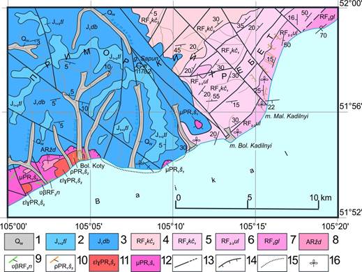
Fig. 3. Geological structure of the western coast of Lake Baikal in the vicinity of the Bolshie Koty village. Modified after (Geological map..., 1964).
1 – Quaternary alluvial deposits; 2–3 – continental alluvial Jurassic deposits of the Baikal mountain facies: 2 – Taltsine formation: sandstones, siltstones, mudstones, 3 – Dabata formation: conglomerates with sandstone interlayers; 4–7 – Baikal Riphean Marine Series: 4 – Upper Riphean Kachergat Formation Upper Subformation: argillaceous-siltstone schists, siltstone-sandstones, slates, sandstones, limestones, 5 – Upper Riphean Kachergat Formation Lower subformation: sandstones, mudstones, carbonaceous shales, conglomerates, 6 – Middle Upper Riphean Uluntuy Formation: algal and stromatolite weakly marbled limestones and dolomites, phyllites, 7 – Middle Riphean Golousten Formation: quartz sandstones, dolomitic weakly marbled limestones, phyllites; 8 – Archean highly metamorphosed Sharyzhalgai series, Yiddish formation: biotite, garnet-biotite gneisses, granitogneisses; 9 – Late Eriphean Nersinsky gabbro-dolerite dike complex; 10–12 – Early Proterozoic Shumikhinsky moderately alkaline intrusive-dike complex: 10 – dikes of pegmatites and aplites of the second phase, 11 – leucogranites of the second phase, 12 – monzonite-diorites of the first phase; 13 – reliable and assumed faults; 14 – thrusts; 15 – thrusts under the waters of Lake Baikal; 16 – places of collection of flora residues.
Рис. 3. Геологическое строение западного побережья оз. Байкал в окрестностях пос. Бол. Коты (Геологическая карта..., 1964, с изменениями и дополнениями).
1 – четвертичные аллювиальные отложения; 2–3 – континентальные аллювиальные юрские отложения байкальской горной фации: 2 – тальцинская свита: песчаники, алевролиты, аргиллиты, 3 – дабатская свита: конгломераты с прослоями песчаников; 4–7 – байкальская рифейская морская серия: 4 – верхнерифейская кaчергатская свита верхняя подсвита: глинисто-алевролитовые сланцы, алевролито-песчаники, аспидные сланцы, песчаники, известняки, 5 – верхнерифейская кaчергатская свита нижняя подсвита: песчаники, аргиллиты, углеродистые глинистые сланцы, конгломераты, 6 – средне-верхнерифейская улунтуйская свита: водорослевые и строматолитовые слабомраморизованные известняки и доломиты, филлиты, 7 – среднерифейская голоустенская свита: кварцевые песчаники, доломитизированные слабомраморизованные известняки, филлиты; 8 – архейская высокометаморфизованная шарыжалгайская серия, жидойская свита: биотитовые, гранат-биотитовые гнейсы, гранитогнейсы; 9 – позднерифейский нерсинский габбро-долеритовый дайковый комплекс; 10–12 – раннепротерозойский шумихинский умеренно щелочной интрузивно-дайковый комплекс: 10 – дайки пегматитов и аплитов второй фазы, 11 – лейкограниты второй фазы, 12 – монцонит-диориты первой фазы; 13 – разломы достоверные и предполагаемые; 14 – надвиги; 15 – надвиги под водами Байкала; 16 – места сборов остатков флоры.
Stratigraphy
Stratigraphic formations in this area show rocks of the Archean, Proterozoic acrotem, Jurassic and Quaternary systems.
Archean Acrotem (AR) Sharyzhalgai Series
Archean deposits are observed along the Primorsky Ridge from the village of Listvyanka in a northerly direction and end 5–6 km along the shore from the Bolshie Koty village. In the vicinity of the village there is a small clip of outcrops of these rocks to the west of the village (Archaean rocks). Fig. 3).
Mid-Upper Riphean (RF2-3) (?) Baikal series
Uluntuy Formation RF2-3ul
In the lower part of the formation section, siltstones and argillaceous schists prevail with thin interlayers and lenses of dark-gray limestones, quartz sandstones, talc-carbonate and carbonaceous schists. In the middle part, there is essentially carbonate, composed of algal limestones and dolomites, among which thin layers of talc-carbonate schists occasionally appear. In the Malaya Kadilnaya valley, in the section of organogenic limestone and dolomite, stromatolites and microphytolites of the middle-late Riphean age (Figs 4–8) were found, such as Conophyton garganicus Kor., Conophyton cadilnicus Kor., Jacutophyton ramosum Schap., Baicalia baicalica Kryl, as well as stratum stromatolites and microphytolites. The Upper Uluntui unit contains 19 forms of stromatolites. In the Kurtun and Goloustnaya, there are stromatolites В. гага Semikh, Microphytoliths Osagia columnata Reitl., O. tschaica Yak., O. undosa Reitl, as well as microfossils Leiosphaeridia div. sp., Leiominuscula sp., и Осtaedrixium pntulai (Rud.) и др. (Geological map..., 1962; Dolnik, Nikolsky, 1962).
The formations are not sustained along strike and have variable facies. The maximum thickness of the formation in this area does not exceed 400 m. Terrigenous rocks of the Uluntui formation have oligomictic or quartz composition. Horizontal and wavy layering, breccia-like and organogenic textures are widespread in these rocks.

Fig. 4. Outcrops of stromatolite limestones of the Middle Riphean Uluntui formation at the mouth of the Malaya Kadilnaya valley, site 33-08*, photo 1275pan.
Рис. 4. Обнажения строматолитовых известняков улунтуйской свиты среднего рифея в устье пади Малая Кадильная, т.н. 33-08, фото 1275пан.
[* For each observation point there is a hyperlink where you can download a file indicating its location on the satellite im-age in the Google Earth program. If you want to download and view all the observation points and tracks mentioned in the article at once using the MapSource program, then you need to download this file kad2025.gdb].
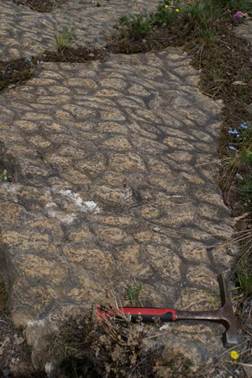
Fig. 5. The surface of the strata (roof) of the limestone layer of the Uluntui formation, emphasized by the upper parts of the columns of stromatolites of Conophyton cadilnicus Kor., site 49-09. photo 1380.
Рис. 5. Поверхность напластования (кровля) слоя известняков улунтуйской свиты, подчеркнутая верхними частями столбиков строматолитов Conophyton cadilnicus Kor., т.н.49-09. фото 1380.
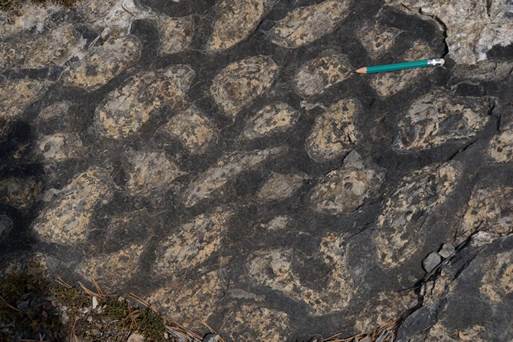
Fig. 6. Close-up surface of strata of stromatolite limestone, fragment of Fig. 5, photo 1381.
Рис. 6. Поверхность напластования строматолитовых известняков крупным планом, фрагмент рис. 5, фото 1381.
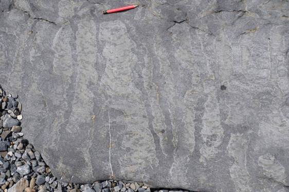
Fig. 7. Structure of stromatolite columns in the vertical plane, site 33b, photo 1388.
Рис. 7. Строение строматолитовых столбиков в вертикальной плоскости, т.н. 33b, фото 1388.
Fig. 8. Limestone outcrop of the Uluntui formation, left side of the estuary part of the Malaya Kadilnaya valley, view to the northeast, photo 1982-84.
Рис. 8. Обнажение известняков улунтуйской свиты, левый борт приустьевой части пади Мал. Кадильная, вид на северо-восток, фото 1982-84.
Kachergat Formation RF3kč
The deposits of the formation are generally consistent on the rocks of the Uluntui Formation, and only in some areas (Cape Bolshoy Kadilny) at the base of the formation are lenses of basal gravelites and conglomerates, the pebbles of which are represented by the rocks of the Uluntui Formation.
The formation is divided into two subformations. Lower (RF3kč1) it is represented by sandstones, siltstones, mudstones and carbonaceous schists. The thickness of the subformation varies from 286 to 820 m.
Upper subformation (RF3 kč2) is composed of polymictic sandstones (Figs 9–10), carbonaceous-argillaceous schists, siltstones, and mudstones with rare interlayers of conglomerates and dolomites. The subformation is as thick as 647 m.
Rocks of the lower subformation show microfossils: Leiosphacridia div. sp., Pterospermopsimorpha div. sp., Nucellosphacra sp., N. marginata Fajz. et Stan, and others. In the rocks of the upper part of the section of the upper subformation, in addition to the forms established in the lower subformation, there are microfossils Aducta sibirica Fajz., Bailicania div. sp., Micrhystridium div. sp. и др. (Geological map..., 1962; Dolnik, Nikolsky, 1962).
Rocks of the formation occur in the area of the Devil's Most tract, located about 7–8 km from the Bolshie Koty village to the east or in the vicinity of the cardoon at Cape Bolshoi Censer. Late Riphean microfossils occur in outcrops of the formation along the Goloustnaya River.
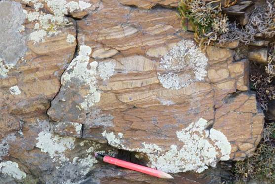
Fig. 9. Coarse-grained sandstone of the Kachergat formation, site 41-09, photo 1359.
Рис. 9. Песчаник крупнозернистый кaчергатской свиты, т.н. 41-09, фото 1359.
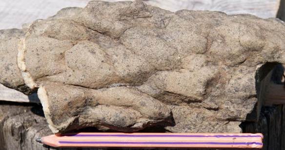
Fig. 10.Wave-breaking signs in sandstones of the Kachergat formation, photo 1363a.
Рис. 10. Волноприбойные знаки в песчаниках кaчергатской свиты, фото 1363а.
Jurassic deposits have been well studied (Skoblo et al., 2001; Akulov et al., 2015). These are observed on the coast of Lake Baikal and on the Primorsky Ridge within the Angara-Kotinsky depression and belong to the Dabat Taltsine, and Koty formations (Fig. 11).
In the Bolshie and Malye Koty area, Jurassic deposits are overthrusted by Precambrian rocks along the system of gentle displacements of the Angara thrust.
Deposits of the Dabat Formation are represented by alluvial terrigenous rocks: conglomerates, less often by rare interlayers of coarse-grained sandstones and siltstone-argillites. The latter, as a rule, are accompanied by thin beds of brown coal. The conglomerates are dominated by pebbles of volcanic rocks — porphyries. Flint and quartz pebbles are less common. Granites, crystalline schists, and other rocks are rare (Fig. 19). Density of conglomerates varies from loose to very dense. A cement of loose conglomerates is sandy-argillaceous. A cement of dense conglomerates is argillaceous-carbonate and argillaceous-carbonate-sandy. Sandstones are polymictic, various-grained, relatively loose, yellow, with a greenish tint, light gray to white, gray, without any clear separation.
The Taltsine Formation within the study area is also composed of conglomerates, but with a higher content of rare sandstone interlayers (Fig. 11) with plant remains of the Middle Jurassic epoch: Ginkgo sibirica Heer; Sphenobaiera; Coniopteris; Equisetites; Czekanwskia и др. Sandstones are light gray, sometimes bluish-gray, greenish-gray and yellowish-cream.
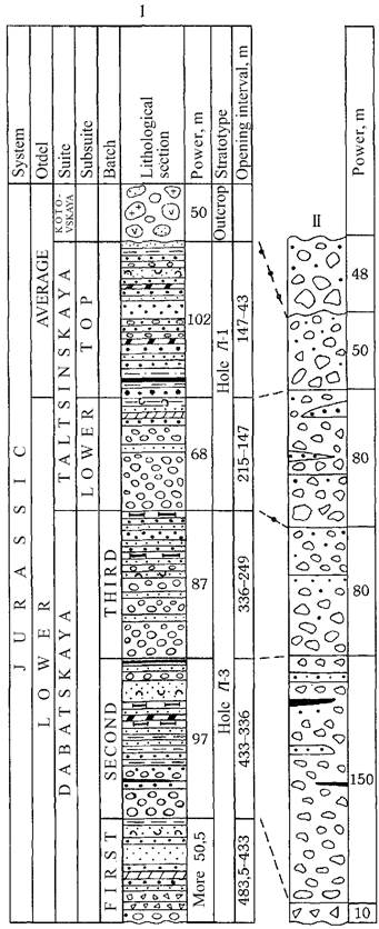
Fig. 11. Scheme of division and correlation of Jurassic sediment sections in the Angara-Koty depression (I – central, II – piedmont parts of the depression) after (Shurygin and Ankudimova, 1981).
Рис. 11. Схема расчленения и корреляции разрезов юрских отложений в Ангаро-Котинской впадине (I – центральная, II – предгорная части впадины) (Шурыгин, Анкудимова, 1981).
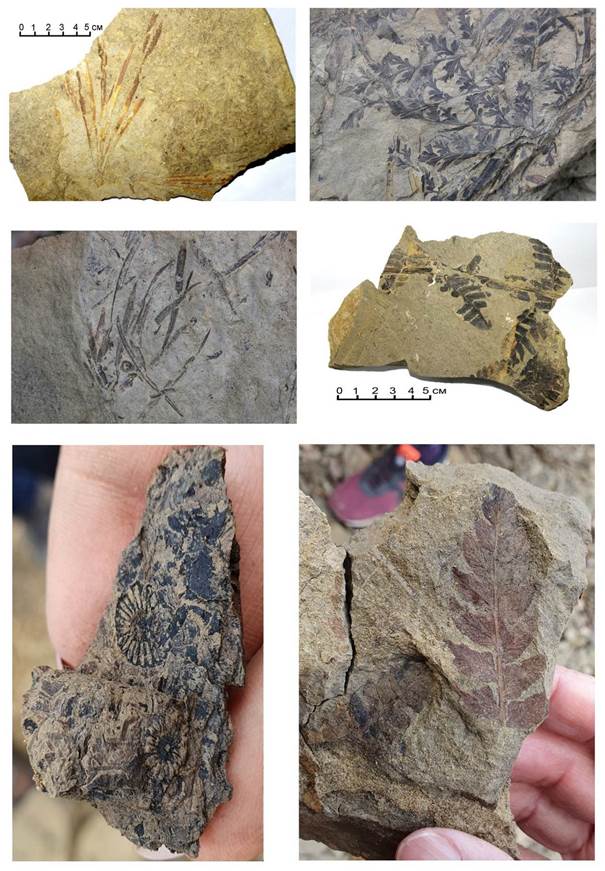
Fig. 12. Plant remains of Middle Jurassic age in coastal outcrops of the left bank of the Irkutsk Reservoir (Kovalenko et al., 2023).
Рис. 12. Растительные остатки среднеюрской эпохи в береговых обнажениях левого берега Иркутского водохранилища (Коваленко и др., 2023).
Quartz and feldspars predominate in sandstone fragments, fragments of siliceous and siliceous-micaceous rocks are present in smaller quantities. Plates of colorless mica are noted. Potassium feldspars and plagioclases are slightly altered. Fragments is of mainly semicircular, angular-rounded, less often angular shape. Siltstone (0.01–0.1 mm) to sandy (0.1–1.0 mm) material predominates. Gravel grains up to 2.2 mm in size occur also. Clastic material is up to 80 % of a cement that usually cosistts of chlorite, less often kaolinite (light-colored varieties).
Outcrops of Jurassic conglomerates with gravelite and sandy cement are observed along the shore of Lake Baikal at the interval of the Great Baikal Trail from the Bolshie Koty village to the Devil's Bridge tract, where outcrops are as high as 30 m (Figs 13–15).
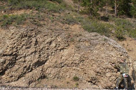
Рис. 13. Обнажение юрских конгломератов на берегу оз. Байкал недалеко от пос. Бол. Коты.
Fig. 13. Jurassic conglomerate outcrop on the shore of Lake Baikal near the Bolshie Koty village.
Fig. 14. Outcrop of Jurassic conglomerates of the Skriper rock, photo 1329a.
Рис. 14. Обнажение юрских конгломератов скальника Скрипер, фото 1329а.
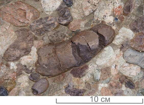
Fig. 15. Fissured cherry pebbles of trachydacite-rhyolite composition in the Jurassic conglomerates of the Bolshiye Koty area, site 25-08, photo 1344 (Mongush et al., 2023).
Рис. 15. Трещиноватые вишневые гальки трахадацит-риолитового состава в юрских конгломератах района Больших Котов, т.н. 25-08, фото 1344 (Монгуш и др., 2023).

Fig. 16. Statistical petrographic sampling of pebbles from Jurassic conglomerates at Skriper, site 38-09 (Kovalenko et al., 2023).
Рис. 16. Отбор статистической петрографической пробы галек из юрских конгломератов на г. Скрипер, т.н. 24-06, 38-09 (Коваленко и др., 2023).
Jurassic conglomerates on the coast of Lake Baikal are an accumulation of well-rounded pebbles of various composition and size in sandstones of the type described above (Figs 17–18), which forms a cement of basal-type conglomerates. The average size of pebbles is 3–8 cm, but some pebbles reach 30 cm in diameter (Figs 17–18). In conglomerates, there are many (up to 70 %) pebbles of acid porphyry of various shades of cherry color (Fig. 18). There are also pebbles of granites such as alaska and, rarely, quartzite, gneiss, and quartz.
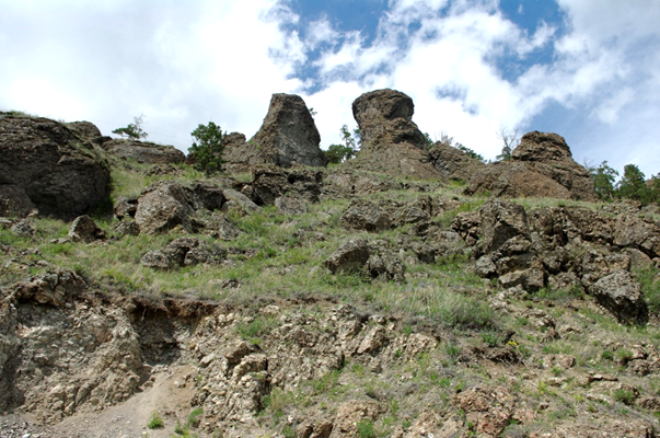
Fig. 17. Terrace-like weathering forms of Jurassic conglomerates on a slope of Lake Baikal. Three terraces of approximately equal height are observed. View from site 25-08.
Рис. 17. Формы выветривания конгломератов юрской системы, подчеркивающие террасированность склона Байкала. Хорошо выделяются три террасы примерно равной высоты. Вид с т.н. 25-08.
Conglomerates are distributed mainly along the boundary of Jurassic deposits, apparently indicating the proximity of the latter to the border of the Jurassic sedimentary basin. Conglomerates occur in the coastal strip of Lake Baikal, where they form thick strata with rare interlayers of sandstones, and where the pebbles of conglomerates are much larger than in the areas located to the west, i.e. in inner potion of the Siberian platform. This change indicates the direction of material transfer from east to west.

Рис. 18. Конгломерат с крупным валуном на скальнике Скрипер в т.н. 38-09, фотография 1894, 2009 г. (а) и «плавающие гальки» в конгломерате, т.н. 25-08 (координаты: 51.89847° с. ш., 105.14131° в. д.), фотография 1342а (б). На фотографии б стрелками показаны гальки эффузивных пород среднего-кислого состава (Олиферовский и др., 2022).
Fig. 18. A conglomerate with a large boulder on the Skriper cliff in site 38-09, photograph 1894, 2009 (a) and “floating pebbles” in a conglomerate, in site 25-08 (N51.89847°, E105.14131°), photograph 1342a (б). Arrows in photo б show pebbles of effusive rocks of intermediate-silicic composition (Oliferovsky et al., 2022).
The fact that in the Jurassic time the introduction of coarse-clastic material was transferred mainly from the eastern and northern territories of the Baikal region, and not from the southwest and west, is evidenced by occurence in the Jurassic of pebbles of Proterozoic quartz porphyries (subvolcanic rocks) (Fig. 19). The presence of these pebbles makes it possible to unmistakably distinguish Jurassic conglomerates from older ones in the field.
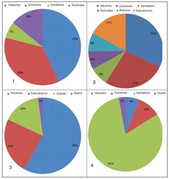
Fig. 19. Petrographic composition of Jurassic pebbles at various observation points of the western coast of Lake Baikal (Kovalenko et al., 2023). 1 – on a pebble beach near the mouth of Abuneeva Falls, 2–3 – from outcrops of Jurassic conglomerates: 2 – in the Bolshie Kotov area (Fig. 13), 3 – on Skriper cliff (Figs 14, 16); 4 – Manzurka alluvium (N2-QE mn) in the Bolshoe Goloustnoe.
Рис. 19. Петрографический состав юрских галек в различных точках наблюдения западного побережья оз. Байкал (Коваленко и др., 2023). 1 – на галечном пляже в районе устья пади Абунеева, 2–3 – из обнажений юрского конгломерата: 2 – в районе Бол. Котов (рис. 13), 3 – на утёсе Скрипер (рис. 14, 16); 4 – манзурского аллювия (N2–QE mn) в районе Бол. Голоустного.

Fig. 20. Devil's Bridge on the Seagull Cliff of Jurassic conglomerates.
Рис. 20. Чертов Мост на Чаячьем Утесе юрских конгломератов.
Sandstones and siltstones with interlayers of brown coal in the Jurassic deposits are widespread on the inner part of the Siberian platform, much west of Lake Baikal, where there are outcrops suitable for study on the left bank of the Irkutsk reservoir near the dam.
Jurassic sediments are slightly dislocated. The angles of incidence of them are no more than 15°. They lie sharply transgressively on sediments of all ages from the Archean to the Cambrian. Steeply diping Jurassic deposits are observed near the Angara thrust, 6 km downstream of the Angara River from its source (on the right bank) and in the vicinity of the Bolshie Koty village (Fig. 2) placed vertically or even overturned.
On the shore of Lake Baikal, sediments often bear traces of frost processes (Figs 21–27).
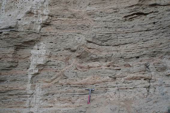
Fig. 21. Inflows of loose clayey material from the lower horizon. Deluvial-nival deposits (d-gQP) of the alluvial cone of the Solontsov valley, site 30-09, 22-15, photo 1262.
Рис. 21. Втеки рыхлого глинистого материала с нижнего горизонта. Делювиально-нивальные отложения (d-gQP) конуса выноса пади Солонцова, т.н. 30-09, 22-15, фото 1262.

Fig. 22. Deformed layers of proluvial material on the shore of Lake Baikal, site 30-09, 22-15, photo 1267.
Рис. 22. Деформированные слои пролювиальных отложений на берегу Байкала, т.н. 30-09, 22-15, фото 1267.
Fig. 23. A pocket sinkhole in the loose rocks of the deluvial-nival deposits of the alluvial cone of the Solontsov valley, formed on the site of an ice vertical dike, site 30-09, 22-15, photo 1286.
Рис. 23. Провал-карман в рыхлых породах делювиально-нивальных отложений конуса выноса пади Солонцова, образовавшийся на месте ледяной вертикальной дайки, т.н. 30-09, 22-15, фото 1286.

Fig. 24. Overlapping of deluvial-nival deposits with modern deluvial material, site 30-09, 22-15, photo 1289.
Рис. 24. Перекрытие делювиально-нивальных отложений современными делювиальными, т.н. 30-09, 22-15, фото 1289.

Fig. 25. Landslide deformations in loose rocks of deluvial-nival deposits of the alluvial cone of the Solontsov valley, photo 1297.
Рис. 25. Оползневые деформации в рыхлых породах делювиально-нивальных отложений конуса выноса пади Солонцова, фото 1297.
Fig. 26. A large fragment of porphyritic granite in loose deluvial-nival deposits of the alluvial cone of the Solontsov valley, site 30-09, 22-15, photo 1300.
Рис. 26. Крупный обломок порфировидного гранита в рыхлых делювиально-нивальных отложениях конуса выноса пади Солонцова, т.н. 30-09, 22-15, фото 1300.
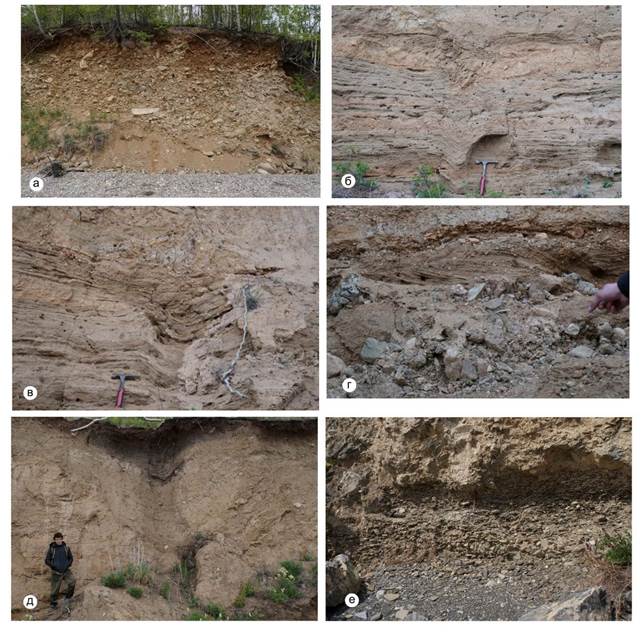
Fig. 27. Character of loose deposits of proluvial cone outcrops.
a – proluvial sediments (pQP) of the Solontsov head cone; б – brittle deformations in loose rocks of dealluvial-nival deposits of the Solontsov head cone; в – dip pocket in loose rocks of dealluvial-nival deposits of the Solontsov head cone, formed on the site of an ice vertical dike; г – oblique foliation in loose rocks of dealluvial-nival deposits of the Solontsov removal cone; д – ditch pocket in loose rocks of dealluvial-nival deposits of the Solontsov removal cone, formed at the place of the ice vertical dike; е – lake sediments (pebbles) at the base of the proluvial removal cone of the Malaya Kadilova Pad. Kadilnaya.
Рис. 27. Характер рыхлых отложений пролювиальных конусов выноса.
а – пролювиальные отложения (pQP) конуса выноса пади Солонцова; б – хрупкие деформации в рыхлых породах делювиально-нивальных отложений конуса выноса пади Солонцова; в – провал-карман в рыхлых породах делювиально-нивальных отложений конуса выноса пади Солонцова, образовавшийся на месте ледяной вертикальной дайки; г – косая слоистость в рыхлых породах делювиально-нивальных отложений конуса выноса пади Солонцова; д – провал-карман в рыхлых породах делювиально-нивальных отложений конуса выноса пади Солонцова, образовавшийся на месте ледяной вертикальной дайки; е – озерные отложения (галечник) в основании пролювиального конуса выноса пади Мал. Кадильная.
Magmatic complexes
Magmatic intrusives are observed mainly in the Sharyzhalgai uplift of the Siberian platform basement (Fig. 1), where the Late Archean ultrametamorphic gneiss-granite Kitoi and the Early Proterozoic Shumikhinsky (previously described as Primorial) alkaline complex of granites and granodiorites have been recognized. Within the study area, the former complex is not observed, and the latter is represented by three, clearly separable intrusion phases (Figs 28–30) from porphyritic and uniform-grained fine-grained granites to granodiorites and pegmatites with sharp boundaries. In the first phase, displayed in the area to the west, small intrusions of diorites were formed. The second phase includes medium- and coarse-grained, often porphyritic biotite, hornblende and biotite-hornblende granites and granodiorites, rarely pegmatites, and the third phase includes fine- and medium-grained biotite, amphibole-biotite and leucocratic granites.
Veins of quartz-microcline pegmatites make up small-shaped and lenticular-vein bodies from 0.2–0.3 cm to 2 m thick.

Fig. 28. Relationship between various intrusive phases of the Early Proterozoic Shumikhinsky complex in the vicinity of Bolshie Koty. Sketch of a block.
1 – xenoliths of biotitized amphibolites; 2 – subalkaline granodiorites and porphyritic granites of the first phase; 3 – granite-pegmatites and pegmatites of the second phase (daikovo-vein); 4 – two-mica fine-medium-grained and aplite granites of the third phase.
Рис. 28. Взаимоотношение различных интрузивных фаз раннепротерозойского шумихинского комплекса в окрестностях Бол. Котов. Зарисовка глыбы.
1 – ксенолиты биотитизированных амфиболитов; 2 – субщелочные гранодиориты и порфировидные граниты первой фазы; 3 – гранит-пегматиты и пегматиты второй фазы (дайково-жильной); 4 – двуслюдяные мелко-среднезернистые и аплитовые граниты третьей фазы.
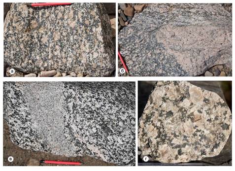
Fig. 29. Varieties of the main magmatic phases of the Early Proterozoic Primorsky complex.
a – porphyritic granodiorite; b – interaction of porphyritic granodiorite with porphyritic granite; c – relationship of fine-grained granites with porphyritic granodiorite; d – porphyritic granite.
Рис. 29. Разновидности основных магматических фаз раннепротерозойского приморского комплекса.
а – порфировидный гранодиорит; б – взаимодействие порфировидного гранодиорита с порфировидным гранитом; в – взаимоотношения мелкозернистых гранитов с порфировидным гранодиоритом; г – порфировидный гранит.
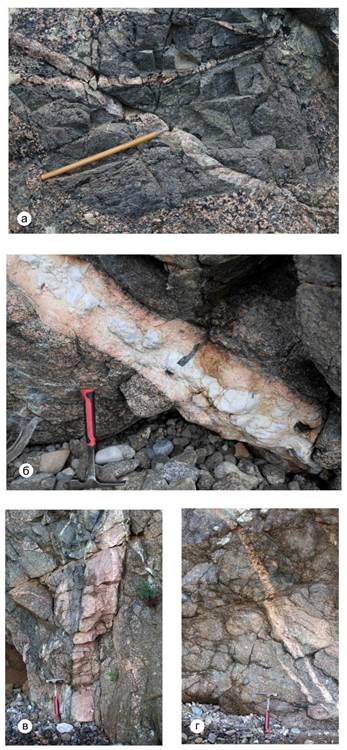
Fig. 30. Veins of the Early Proterozoic Shumikhinsky complex.
a – xenolith of amphibolite along the basic rock in porphyritic granodiorite of the Early Proterozoic maritime complex, additionally broken by veins of the same granodiorites; б – vein of block granite pegmatite with amphibole; в-г – veins of granite pegmatite.
Рис. 30. Жилы раннепротерозойского шумихинского комплекса.
а – ксенолит амфиболита по основной породе в порфировидном гранодиорите, дополнительно прорванный жилами тех же гранодиоритов; б – жила блокового гранитного пегматита с амфиболом; в–г – жилы гранитного пегматита.
Tectonic structure
The area under consideration is situated at the junction between the basement of the Siberian platform and its cover. Tectonic deformations developed in a wide time range from the Archean to the present, at least 3.5 billion years. Three structural levels – the Archean-Early Proterozoic metamorphological-magmatic basement of the Siberian platform, weakly deformed sedimentary cover, and Cenozoic Baikal rift unit – are distinguished in the vicinity of the Bolshie Koty village (Fig. 31). Structures of the sedimentary cover are subdivided into folded Riphean and horizontally lying continental Middle Jurassic sedimentary units.
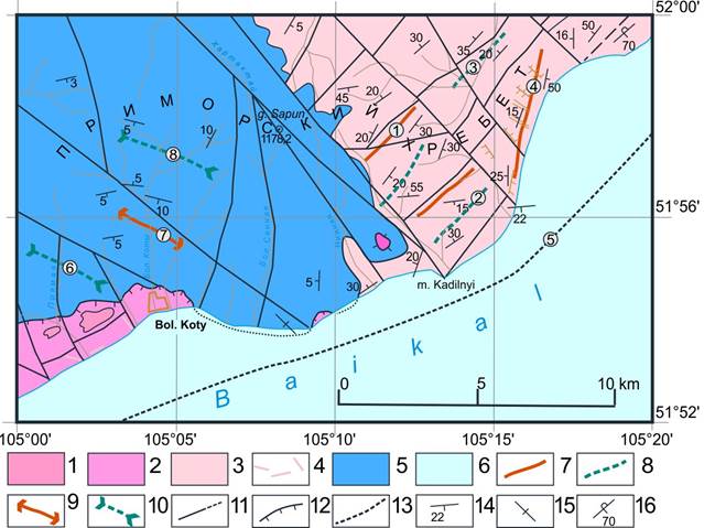
Fig. 31. Tectonic scheme of the western coast of Lake Baikal in the vicinity of the Bolshie Koty village (Geological map..., 1964).
1–2 – 1st Archean-Early Proterozoic metamorpho-magmatic structural-material floor. Crystalline basement of the Siberian platform: 1 – migmatized structures of the granulite-charnokite Yiddish formation of the Archean Sharyzhalgai series, 2 – moderately alkaline Early Proterozoic intrusions of the Shumikhinsky complex; 3–4 – 2nd structural-material floor. Sedimentary cover of the Siberian platform: 3 – folded Riphean stage composed of sedimentary marine rocks of the Baikal Middle Upper Riphean series, 4 – dikes of the Late Eriphean Nersinsky gabbro-dolerite complex; 5 – Jurassic structural-material stage (Angara-Kotinsky intermontane depression) with gently occurring continental sedimentary rocks of the Dabata and Taltsine formations; 6 – 3rd structural-material floor – Cenozoic, vaulted, Baikal-rift; 7 – axes of anticlinal linear folds; 8 – axes of synclinal linear folds; 9 – long axes of brachyanticlines; 10 – long axes of brachysynclines; 11 – faults; 12 – Angara thrust; 13 – Obruchevsky fault; 14–16 – bedding of layering: 14 – inclined, 15 – vertical, 16 – overturned.
The following structures are marked with numbers in the circles: 1 – Kadilninskaya anticline, 2 – Malokadilninskaya syncline, 3 – Verkhne-Undun-Davanskaya syncline, 4 – Bolshekadilninskaya anticline, 5 – Obruchevsky fault, 6 – Krestovskaya brachysyncline, 7 – Cheremshanskaya brachyanticline, 8 – Kotinskaya brachysyncline.
Рис. 31. Тектоническая схема западного побережья оз. Байкал в окрестностях пос. Бол. Коты (Геологическая карта..., 1964).
1–2 – 1-й архейско-раннепротерозойский метаморфо-магматический структурно-вещественный этаж. Кристаллический фундамент Сибирской платформы: 1 – мигматизированные структуры гранулит-чарнокитовой жидойской свиты архейской шарыжалгайской серии, 2 – умеренно-щелочные раннепротерозойские интрузии шумихинского комплекса; 3–4 – 2-й структурно-вещественный этаж. Осадочный чехол Сибирской платформы: 3 – складчатый рифейский ярус сложенный осадочными морскими породами байкальской средне-верхнерифейской серии, 4 – дайки позднерифейского нерсинского габбро-долеритового комплекса; 5 – юрский структурно-вещественный ярус (Ангаро-Котинская межгорная впадина) с полого залегающими континентальными осадочными породами дабатской и тальцинской свит; 6 – 3-й структурно-вещественный этаж — кайнозойский, сводовый, байкало-рифтовый; 7 – оси антиклинальных линейных складок; 8 – оси синклинальных линейных складок; 9 – длинные оси брахиантиклиналей; 10 – длинные оси брахисинклиналей; 11 – разломы; 12 – Ангарский надвиг; 13 – Обручевский сброс; 14–16 – залегание слоистости: 14 – наклонное, 15 – вертикальное, 16 – опрокинутое.
Цифрами в кружках отмечены структуры: 1 – Кадильнинская антиклиналь, 2 – Малокадильнинская синклиналь, 3 – Верхне-Ундун-Даванская синклиналь, 4 – Большекадильнинская антиклиналь, 5 – Обручевский сброс, 6 – Крестовская брахисинклиналь, 7 – Черемшанская брахиантиклиналь, 8 – Котинская брахисинклиналь.
Archean-Early Proterozoic basement of the Siberian platform
The Archean complexes are exposed within the Sharyzhalgai tectonic block (Fig. 1) – the Siberian platform basement. The rocks were affected by metamorphism under conditions of granulite and amphibolite facies. These are biotite-hypersthen gneisses with layers of amphibole and biotite-sillimanite schists and rare lenses of marbles and quartzites. These rocks occur as small xenoliths within Proterozoic granites. The granitoids of the Shumikhinsky complex are characterized by moderate alkalinity and form linear-elongated massifs located along large faults of long-term development, therefore they are strongly affected by dynamometamorphism with the formation of various tectonites (Fig. 33) up to the development of spectacled blastomylonites (Fig. 32).
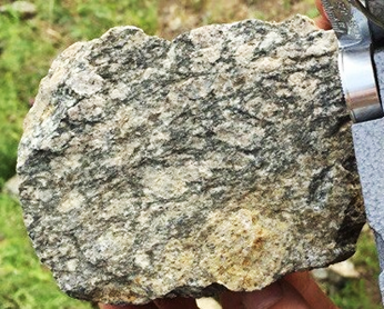
Fig. 32. Spectacled blastomylonite with large feldspar porphyroblasts.
Рис. 32. Очковый бластомилонит с крупными порфиробластами полевого шпата.

Fig. 33. Ocal and ocal-striped blastomylonite (a, б) and kakiritization of Shumikhinsky granites (в).
Рис. 33. Очковый и очково-полосчатый бластомилонит (а, б) и какиритизация шумихинских гранитов (в).
Rephean and Jurasic units of sedimentary cover of the Siberian platform
The Riphean formations of the sedimentary Baikal series are involved in complex unevenly manifested folded deformations (Figs 34–35), sometimes accompanying thrust structures (Fig. 36).
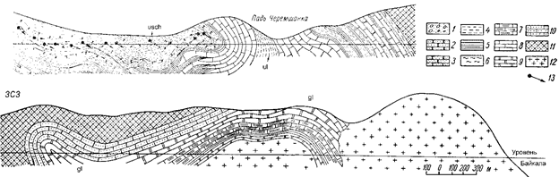
Fig. 34. Geological section after (Prytula et al., 1962).
1 – conglomerates, 2 – gravelites, 3 – sandstones of different grains, 4 – siltstones and mudstones, 5 – clayey carbonaceous shales, 6 – variegated shales, 7 – calcareous schists, 8 – limestones, 9 – dolomites, 10 – carbonate-quartz rocks, 11 – quartzites, 12 – granites, 13 – observation points and lines of dip of strata in the section.
Рис. 34. Геологический разрез (Притула и др., 1962).
1 – конгломераты, 2 – гравелиты, 3 – песчаники разнозернистые, 4 – алевролиты и аргиллиты, 5 – сланцы глинистые углистые, 6 – сланцы пестроцветные, 7 – сланцы известковистые, 8 – известняки, 9 – доломиты, 10 – карбонатно-кварцевые породы, 11 – кварциты, 12 – граниты, 13 – точки наблюдения и линии падения пластов на разрезе.
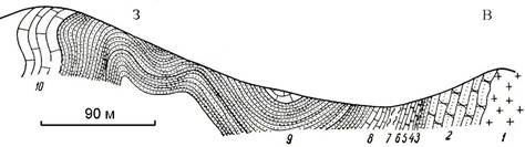
Fig. 35. The section in the area of the Malaya Cheremshanka valley after (Prytula et al., 1962).
1 – alaskite granites, coarse-grained; 2 – quartzite-like sandstones and gravelites are light, at the end of the interval there is a five-meter layer of gray schist sandstones; 3 – black finely fragmented clayey shales; 4 – silicified dolomite, dark gray, with thin layers of dark clayey shale; 5 – quartzite-like (confluent) dark-gray and brown quartz sandstones; 6 – dark limestone with clayey shales; 7 – alternation of crimson and yellowish-green siltstone schists, silicified; 8 – dark thin-bedded limestone with oolitic interlayers; 9 – green well-bedded, fine-grained sandstones and siltstones; 10 – dark crystalline limestones.
Рис. 35. Разрез в районе пади Мал. Черемшанка (по Притула и др., 1962).
1 – аляскитовые граниты, крупнозернистые; 2 – кварцитовидные песчаники и гравелиты светлые, в конце интервала пятиметровый пласт серых рассланцованных песчаников; 3 – черные мелкооскольчатые глинистые сланцы; 4 – доломиты окремненные, темно-серые, с тонкими прослойками темных глинистых сланцев; 5 – кварцитовидные (сливные) темно-серые и бурые кварцевые песчаники; 6 – известняки темные с глинистыми сланцами; 7 – чередование малиновых и желтовато-зеленых алевритовых сланцев, окварцованных; 8 – темные тонкослоистые известняки с оолитовыми прослоями; 9 – зеленые четкослоистые, тонкозернистые песчаники и алевролиты; 10 – темные кристаллические известняки.
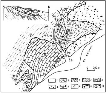
Fig. 36. Geological structure of the Ozerko valley area after (Mazukabzov, Sizykh, 1987).
1 – modern sediments; 2-6 – Upper Riphean: 2 – sandstones, siltstones with interbeds of oncolithic limestones of the Uluntu Formation, 3 – dolomites of the middle sub-formation of the Goloustnaya Formation, 4 – clay-carbonate mottled shales of the lower part of the Goloustnaya Formation, 5 – basal creamy dolomites and siltstones of the Goloustnaya Formation, 6 – gneissogranites; 7 – elements of occurrence (a – layering, б – cleavage, в – banding); 8 – orientation of joints of minor folds; 9 – thrusts; 10 – observation points of the authors of the article.
Рис. 36. Геологическое строение района пади Озерко (Мазукабзов, Сизых, 1987).
1 – современные осадки; 2–6 – верхний рифей: 2 – песчаники, алевролиты с прослоями онколитовых известняков улунтуйской свиты, 3 – доломиты средней подсвиты голоустенской свиты, 4 – глинисто-карбонатные пестрые сланцы низов голоустенской свиты, 5 – базальные кремовые доломиты и алевролиты голоустенской свиты, 6 – гнейсограниты; 7– элементы залегания (а – слоистости, б – кливажа, в – полосчатости); 8 – ориентировка шарниров мелких складок; 9 – надвиги; 10 – точки наблюдения авторов статьи.
The formation of the folds took place under conditions of a single tectonic regime within the zone of long-term basement subsidence at the edge of the platform in the zone of the Baikal marginal pericratonic subsidence or marginal trough. The sedimentary strata of the stage are characterized by a low degree of metamorphism and are dislocated in the folds of the northeastern strike. The folds are asymmetrical, with gentle southeastern and steeper northwestern wings, often thrown back to the northwest in the side of the platform. On the tectonic scheme, the folds are distinguished: Malokadilninskaya syncline, Kadilninskaya and Bolshekadilninskaya anticlines (Fig. 31).
Through geometric analysis, folding of the Riphean complex, fine folding, kink zones, cleavage, slip mirrors and faults, vein igneous complexes (granite-pegmatites, pegmatites, quartz veins, etc.), and ancient stress fields are deciphered (Fig. 37). Normal and inverted fold wings, the location of synclines and anticlines are determined from the main cleavage; by oblique layering, ripple and ripple signs stromatolites – the roof and bottom of sedimentary layers.
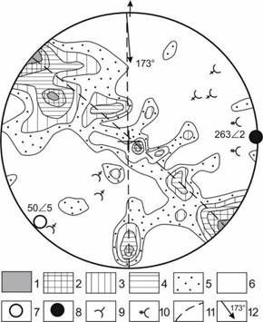
Fig. 37. Geometrical analysis of the structures of the Baikal complex on the Wolfe stereographic grid. The measurements were made along the Baikal western coast in the interval of the mouths of the Nizhnyaya and Malaya Kadilnaya mouthes (Kovalenko et al., 2023).
1–6 – isolines of layering occurrence according to 100 measurements with concentrations: 1 – over 5 %, 2 – 5–4 %, 3 – 4–3 %, 4 – 3–2 %, 5 – 2–1 %, 6 – less than 1 %; 7 – joints of the main folds of the 1st generation (synsedimentary); 8 – joints of the main folds of the 2nd generation; 9 – joints of additional folds of the 1st generation; 10 – joints of additional folds of the 2nd generation; 11 – concentration trajectories of layering measurements.
Рис. 37. Геометрический анализ структур байкальского комплекса на стереографической сетке Вульфа. Замеры произведены вдоль западного берега Байкала на интервале устий падей Нижняя и Мал. Кадильная (Коваленко и др., 2023).
1–6 – изолинии залегания слоистости по 100 измерениям с концентрацией: 1 – более 5 %, 2– 5–4 %, 3 – 4–3 %, 4 – 3–2 %, 5 – 2–1 %, 6 – менее 1 %; 7 – шарниры главных складок 1-й генерации (синседиментационные); 8 – шарниры главных складок 2-й генерации; 9 – шарниры дополнительных складок 1-й генерации; 10 – шарниры дополнительных складок 2-й генерации; 11 – траектории поясов концентрации замеров слоистости.
Through geometric analysis of layering elements in the area, parameters of the main folds of the Baikal Riphean complex was determined. At the same time, it is revealed that the folds of the first generation (F0) are synsedimentary i.e. resulted from sliding of sedimentary strata down the continental slope in the Riphean time. Tectonic folds of the second generation (F1) are those, turn-ups, formed in connection with movements along the thrust planes parallel to the Angara thrust. The dividing line of the direction of movement, determined by the hinges of the folds of the turn-ups, is 173°. The time of movement is post-Jurassic. It was proposed that "Tectonic, thrust deformations occurred about 250 million years after the synsedimentary ones" (Mazukabzov et al., 2006, p. 233).
Elements of the Riphean strata occur far from the Angara thrust (Kachergat, Uluntuy, and Goloustnaya formations) along the shore of Lake Baikal in the interval between the mouths of the river valleys Malaya Kadilnaya and Semenikha (Ozerki) on the spherogram (Fig. 38) form the same northwestern belt of the great circle, but with slightly different parameters: the hinge of the main synsedimentary folds has an abundance of 255°, the angle of the burial is 12°. The axial plane is inclined at an angle of 82° north-northwest along the az. 343°. The shape of the folds is the same, asymmetrical, with fairly gentle (60°) northwestern wings (maximum pS1) and steep (80°) south-east (maximum pS2).
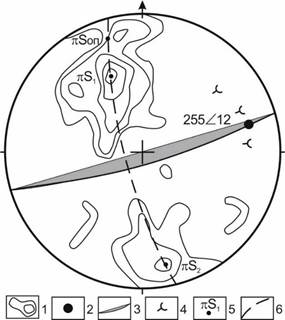
Fig. 38. Geometrical analysis of the structures of the Baikal complex on the Wolfe stereographic grid. The measurements were made along the Baikal coast in the interval of the mouths of the Mal'kadilnaya and Semenikha gorges.
1 – isolines of the layering occurrence based on 70 measurements taken at 8 %, 6 %, 4 %, 2 %, and 1 %; 2 – joint of the main folds of the 1st generation (synsedimentary); 3 – graphical projection of the axial plane of the main folds; 4 – joints of additional folds of the 1st generation; 5 – gnomological projections; 6 – trajectory of concentration belts of layering measurements.
Рис. 38. Геометрический анализ структур байкальского комплекса на стереографической сетке Вульфа. Замеры произведены вдоль берега Байкала на интервале устий падей Мал. Кадильная и Семениха.
1 – изолинии залегания слоистости по 70 измерениям проведены через 8 %, 6 %, 4 %, 2 % и 1 %; 2 – шарнир главных складок 1-й генерации (синседиментационные); 3 – граммапроекция осевой плоскости главных складок; 4 – шарниры дополнительных складок 1-й генерации; 5 – гномопроекции; 6 – траектория поясов концентрации замеров слоистости.
The Jurassic sedimentary strata is composed of deposits that, in terms of lithological and facial features, correspond to intracontinental type of lacustrine-river coal-bearing formations. They infill the Angara-Koty intermontane depression at the southeastern end of the large Sayan piedmont trough. The Angara-Koty depression has a sublatitudinal orientation, stretching from the sources of the Angara to the basin of the Bolshie Koty River valley. directions with angles of incidence from subhorizontal to 10–20°. Within the study area, V.N. Novokshonov defined the Koty brachysyncline and the Cheremshanka brachyanticline. He inferred that "the Koty brachysyncline is a basin elongated in the north-west direction, more than 20 km long and 4 to 6 km wide. In the inner part of the basin, there is a slight uplift with a height of 50–100 m with the Riphean formations. The thickness of the Jurassic deposits in some places decreases to 100–150 m, while within the basins it is about 500 m.
The structure of the Angara-Koty depression in the Late Mesozoic and Cenozoic is largely complicated by discontinuities and is divided into blocks that are unevenly vertically displaced relative to each other. The discontinuities are accompanied by asymmetrical fault folds, which are most intensively manifested in the zone of the Angara thrust."
In the Bolshie Koty area, Jurassic conglomerates and the Archean-Early Proterozoic formations on the surface of the Angara thrust are brought into contact (Fig. 39). The thrust is a geological monument. It is observed not far from the village on the watershed mane, called Scallop by the locals, in a narrow saddle. When approaching it, Proterozoic biotite-hornblende granodiorites, quartz syenites are intensively cataclased, and along the thrust front there is a a series of scales that arch upwards and are well prepared on the exposed slope of the ridge. Their soles have low-power milonite zones. The main zone of the Angara thrust is represented by cataclasites and mylonites up to 20 m thick. The orientation of the layering of sandstones indicates the turn-up of the strata, up to overturning.
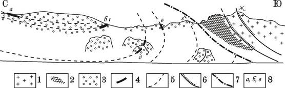
Fig. 39. Exit of the Angara thrust on the left watershed of the Bolshiye Koty valley after (Danilovich, 1941).
1 – granites; 2 – Mylonites; 3 – conglomerates; 4 – sandstone interlayers; 5 – tucked layering of conglomerates; 6 – contacts between scales; 7 – thrust surface; 8 – V.N. Danilovich's observation sites.
Рис. 39. Выход Ангарского надвига на левом водоразделе пади Большие Коты (Данилович, 1941).
1 – граниты; 2 – милониты; 3 – конгломераты; 4 – прослои песчаника; 5 – подвернутая слоистость конгломератов; 6 – контакты между чешуями; 7 – поверхность надвига; 8 – точки наблюдения В.Н. Даниловича.
The continuation of the thrust is traced 100 m to the west of the mouth of the Varnachka valley, where near the thrust plane there is a well-displayed cleavage subparallel to the displacement, in both allochthon and autochthon. In conglomerates and granites, a series of well-defined cracks parallel to the thrust plane, covering the volume of rocks up to hundreds of meters from the displacement, develops equally strongly. At the displacement zone, brown ochre tectonic friction clay, dark gray mylonites and tectonic breccia develop — the entire set of dynamometamorphic rocks is observed in the interval of one or two meters. In the underlying Jurassic conglomerates, layering is well established along two thin sandstone interlayers, 30 and 40 m from the displacement zone. Near the surface of the thrust, the conglomerates are fragmented, layer-by-layer breakdowns and fine folding of the longitudinal bend occur in rock layers.
In the estuary part of the Varnachka valley, in the main outcrops on the shore of Lake Baikal, the elements of the thrust plane were detected and the line of its exit in the relief was built using the stratoisogypsum method on a topographic map of 1 : 25 000 scale. Near the fault plane, a statistical analysis of tectonic fractures using the belt method of V.N. Danilovich (Danilovich, 1961, 1941) showed the orientation of the supposed plane of the Angara thrust (200Ð10), the azimuth of the immersion of the allochthon displacement line (207Ð8), and the stress field from the prevailing series of large fractures (σ1 – 20Ð80, σ2 – 117Ð03, σ3 – 206Ð04) (Fig. 40).

Fig. 40. Analysis of tectonic fracturing in Jurassic conglomerates on the shore of Lake Baikal, 100 m from the mouth of Varnachka Pad. Wolfe grid.
1 – isolines; 2 – trajectories of measuring concentration belts; 3 – graph-projection of presumed plane of Angarsk thrust; 4–6 – positions of the axes of main normal stresses: 4 – tension; 5 – medium; 6 – compression.
Рис. 40. Анализ тектонической трещиноватости в юрских конгломератах на берегу оз. Байкал в 100 м от устья пади Варначка. Сетка Вульфа.
1 – изолинии; 2 – траектории поясов концентрации замеров; 3 – граммапроекция предполагаемой плоскости Ангарского надвига; 4–6 – положение осей главных нормальных напряжений: 4 – растяжения; 5 – средней; 6 – сжатия.
Other outcrops of the Angara thrust in the study area are known on the slope of the Baikal coast, 400 m to the west of Cape Sobolev, where on the Jurassic conglomerates there is a remnant of granitoids of the Shumikhinsky complex (Fig. 41). In plan, it has an oval shape and a diameter of about 20 m. The bottom of the clip is opened by a ditch, where cataclyzed conglomerates, strongly weathered mylonites, and mylonitized cataclyzed granitoids are observed.
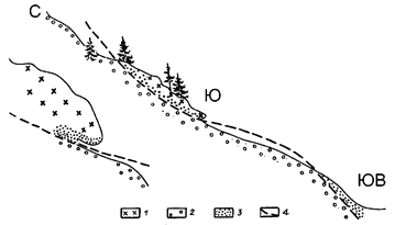
Fig. 41. Scheme of the outlier of the Angara thrust on Sobolev Cape after (Danilovich, 1941).
1 – mylonitized granitoids; 2 – conglomerates; 3 – tectonic breccias and mylonites; 4 – the plane of the thrust. On the left – a sketch of the outcrop at the point S.
Рис. 41. Схема останца Ангарского надвига на мысе Соболев (Данилович, 1941).
1 – гранитоиды милонитизированные; 2 – конгломераты; 3 – тектонические брекчии и милониты; 4 – плоскость надвига. Слева — зарисовка обнажения в точке Ю.
Another place of the outcrop of the Angara thrust plane (bedrocks), where the Proterozoic granites and rocks of the Kachergat formation are thrust over the Jurassic conglomerates, is located in the estuary part of the Nizhnyaya valley. It is observed along the ridge of the left side of the valley to the north, where 900 m from the mouth of the valley site 041a the most representative and intricately constructed clip-remnant of the Angara thrust with a size of 300x600 m is situated.
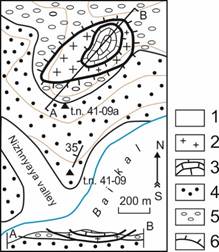
Fig. 42. Geological scheme of the estuary part of the Nizhnyaya valley site 41-09 after (Mazukabzov and Sizykh, 1987).
1 – modern sediments; 2 – granitoids; 3 – carbonate rocks of the Golousten formation; 4 – Riphean terrigenous rocks of the Kachergat formation; 5 – Jurassic rocks; 6 – clip contours.
Рис. 42. Геологическая схема приустьевой части пади Нижняя, т.н. 41-09 (Мазукабзов, Сизых, 1987).
1 – современные осадки; 2 – гранитоиды; 3 – карбонатные породы голоустенской свиты; 4 – рифейские терригенные породы кaчергатской свиты; 5 – породы юры; 6 – контуры клиппа.
The lower plate as thick as 40 m is represented by the Early Proterozoic granitoids of the Shumikhinsky complex; the upper plate of 25–30 m is composed of dolomites of the Riphean Goloustnoe Formation. Granitoids are biotite, less often amphibole-biotite granosienite varieties: dolomites are massive, gray, fine-grained. The bed of the remnant is composed of siltstones, schists of the Riphean Kachergat Formation and Jurassic conglomerates.
The northern and southern boundaries of the granitoid plate are gently sloping thrust surfaces. Near the main tectonic contact, the conglomerates are broken by chipped cracks, along which pebbles are cut, and granitoids are intensively crushed, ferruginized, and rotten. Limonite-hematite mineralization in the form of thin inclusions or enriched screeds covers a zone with a thickness of up to 3 m. Tectonic bkocks of granitoids are 10–12 m thick. The suture of the thrust is composed of variegated cataclasites and thin-banded mylonites corresponding to the concept of "friction clay", into which individual pebbles of conglomerates are pressed.
The main Cenozoic tectonic unit
The main feature of the Cenozoic in this territory is the development of the Baikal rift. It is characterized by formation of deep depressions, as well as the development of thrust tectonics. Its feathering breaks parallel to the main displacement zone are observed (Fig. 44).
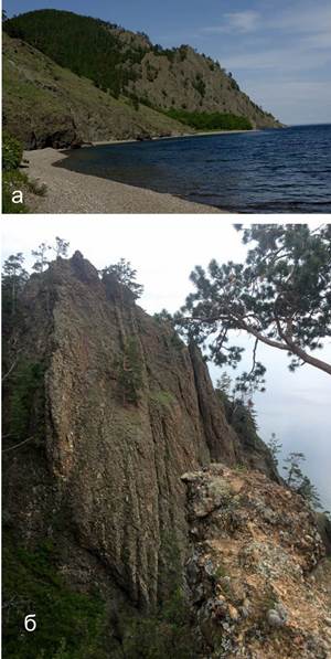
Fig. 44. General view of the Skriper cliff and the mouth of the Sennaya river. photograph 1882, 2009 (a) and view of a fragment of conglomerates dissected by subvertical cracks parallel to the Obruchev fault (б). In foreground of photograph b, clastic material of various sizes is distinguished, from small pebbles to large boulders (Oliferovsky et al., 2022).
Рис. 44. Общий вид утеса Скрипер и устья р. Сенной, фотография 1882, 2009 г. (а) и вид фрагмента конгломератов, разбитых субвертикальными трещинами, параллельными Обручевскому сбросу (б). На переднем плане фотографии б различается обломочный материал разного размера, от мелкой гальки до крупных валунов (Олиферовский и др., 2022).
Geological history of the area
After the formation of the Archean-Lower Proterozoic basement, there was a large break in sedimentation at least until the Late Riphean. At this time the marginal parts of the Siberian platform began subsiding that resulted in sea transgression with depositing terrigenous material, black and green carbonates and stromatolite limestones. The latter formed paleoreefs. Afterwards, there was a slight decrease in the depth of the Riphean basin. Shelf quartz sandstones and olistostroms formed in a passive continental margin.
The Riphean sedimentary rocks lie on the Archean and Proterozoic basement with angular unconformity. At the contact, cream dolomites, located at foot of the Siberian platform cover, occur directly on the basement. This relationship is observed near the Bolshoe Goloustnoe village.
The further history of the region is associated with the formation of a thick stratum of Jurassic conglomerates that accumulated in the late Aalenian (about 173–171 million years ago) along a river valley that crossed a mountain range on the modern water area of Lake Baikal (Oliferovsky et al., 2022; Mongush et al., 2023; Mongush et al., 2024).
The Cenozoic history of the area is associated with the development of the older (Late Cretaceous-Paleogene) depressions in Souther Siberia and younger (Neogene-Quaternary) basins of the Baikal rift system. The Neogene sediments in the depression are 1200–1500 m thick; the Quaternary sediments reach 500 m. Sedimentation began in the Miocene with the accumulation of lacustrine, lacustrine-marsh sediments that were followed with lacustrine and lacustrine-alluvial sediments. In the Early Pliocene, there was a change in the nature of lithogenesis: at this time, sands and pebbles of lacustrine, alluvial, and proluvial genesis began to accumulate, culminating in the deposition of red-colored, variegated rocks in genesis – coarse-clastic and pebbly.
In the Angara-Yenisei serial legend (The Legend of the Angara-Yenisei..., 2008), various researchers distinguish a different number of Baikal terraces – from six (Decisions..., 1983) to nine (Stratigraphy of the USSR..., 1984). The accumulative strata covering the highest Baikal terraces, which exceed the fifth 32–45-meter terrace in height, are composed of the Late Eopleistocene moraine and delayed deglaciation formations of buried glacier ice. In their sediments, along with the remains of the Early Pleistocene fauna (Archidiscodon cf. trogonterii), there are remnants of fauna that did not appear earlier than at the end of the Middle Pleistocene (Mammuthus primigenius, Bison priscus и др.). The formation of lake sediments covering the Baikal terraces from the first to the fifth occurred in accordance with the climatic-stratigraphic model of terrace formation.
Conclusion
After disembarking from the ship in the vicinity of the Bolshaya Kadilnaya kardon on the cape of the same name of the Zapovednoye Pribaikalye National Park, we visit and describe outcrops of dark-gray weakly marbled algal limestones that are situated to the north of the village (site 31-08*) and in the estuary part of the Bolshaya valley. The censer on its port side site 60-10, 42-15, 43-15), which follow 150-200 m upstream on its starboard and port sides. Near the outcrops, there are abandoned kilns, indicating mined and processed limestones in the past.
[* For each observation point there is a hyperlink where you can download a file indicating its location on the satellite im-age in the Google Earth program. If you want to download and view all the observation points and tracks mentioned in the article at once using the MapSource program, then you need to download this file kad2025.gdb].
Occurrence of banding or layering:
in site 31-08 — 155Ð70;
in site 42-15 — 356Ð30;
in site 43-15 — 355Ð45.
In addition to geological research, we perform geomorphological observations of Cape Bolshoi Kadilny (The Baikal Run..., 2009). Geomorphologically, the censer is a wide mouth of the valley and a large alluvial cone. Pebble material on the shore of Lake Baikal, entering the coastal zone of Lake Baikal along the Bolshaya valley. In the western part of the cape, it is composed of flat pebbles of Riphean rocks of the Baikal complex. The pebbles are well rounded. Their accumulation forms a beautiful pattern on the beach. To the east of the mouth of the valley, there are a lot of pebbles of elongated (pencil) shape. Some reach a length of 20-30 cm, which corresponds in size to boulders, but their transverse dimensions do not exceed 10 cm, and their height is less than 1 cm.
Carefully study the topographic map of 1 : 100 000 scale and pay attention to the relief of the summit belt of the Primorsky Range. These are gently convex summit surfaces of the mountains that form a subhorizontal level (the altitude of all peaks lie within 950–1100 m) in front of the Primorsky Ridge. In some places, even weathering crusts have been preserved on it.
Then we continue the route to the Malaya Kadilnaya valley, for which you need to move from the kardon along a good field road in the eastern direction, following which after 2.5 km you need to stop in site Kadilnaya valley 48-09 and visit site 46-09 is an outcrop (Fig. 45), located 230 m north of the route (Pechka2025 track), which offers beautiful view of Lake Baikal. Its height is more than 10 m, width 2–3 m and length up to 5 m, composed of dark-gray limestone layers (47-09) (170Ð35), in which columnar and bedded stromatolites are clearly defined.
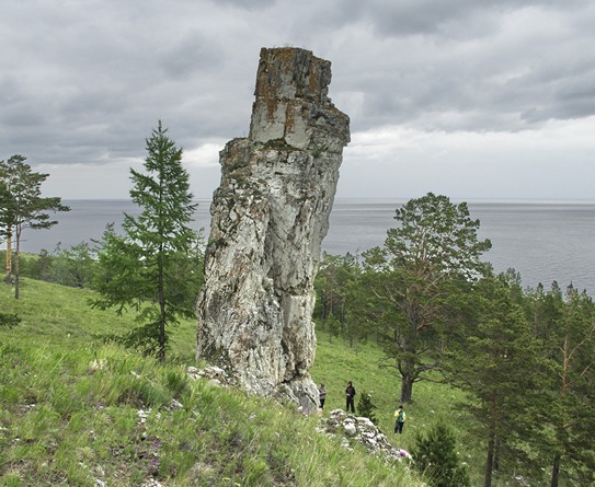
Fig. 45. Outcrop of site 46-09 – gray limestones of the Uluntui formation.
Рис. 45. Обнажение в т.н. 46-09 серых известняков улунтуйской свиты.
Then after 400 m along the route in site on 32-08 we observe outcrops of the Uluntui Upper Proterozoic limestones with a well-deciphered layering. The rocks of the Uluntui formation are traced over 450 m on the left side of the estuary part of the Malaya Kadilnaya valley site 33-08 and 49-09). In site 49-09, spectacular stromatolites are observed, in the plane of layering in the form of rounded formations, and in perpendicular planes in the form of columns with a diameter of up to 0.10–0.15 m and a height of up to 0.3–0.5 m (Figs 4–7). Stromatolites show columnar forms, such as Conophyton garganicus Kor., Conophyton cadilnicus Kor., Baicalia baicalica Kryl. Jacutophyton ramosum Schap., Baicalia baicalica Kryl, as well as stratum stromatolites and microphytolites. The Upper Uluntui Assamblage contains 19 forms of stromatolites. The layering here: 175° and 22°.
In the left side of the Malaya Kadilnaya valley site Camp5-15 we visit numerous caves of ancient man (trek M4-10, t.site 56-10–59-10, 45-15). Including the largest one Malaya Kadilnaya, called the Chapel site 45-15. The wide and low entrance of this cave turns into an even lower and narrower corridor. There is a high round hall about seven meters in diameter, tapering upwards and having a round hole in the sky, through which the smoke of the fire of cavemen escaped. In the center of the cave in the floor there is a pit, traces of excavations. The walls are disfigured by inscriptions of tourists, and the ancient chronicle of hunting for a saber-toothed tiger is no longer visible.
In surrounding area outcrops extend along the left watershed ridge site 57-09–59-09. The route continues toward the mouth of the valley on the pebble beach of Lake Baikal with examination of a cliff of the alluvial cone site 33a — on the shore of Lake Baikal, opposite site 33-08, etc. 49-09. The cliff 5–6 m high (Fig. 46) is composed of two layers of different origin. There is a layer of lake gravel with rounded small pebbles of various rocks and sandy-sandy loam cement. Above it, there is a layer of alluvial-proluvial fine-clastic rock with unrolled or weakly rolled blocks of limestone of local rocks with sandy-clayey cement. Its thickness is 1.0–1.2 m.
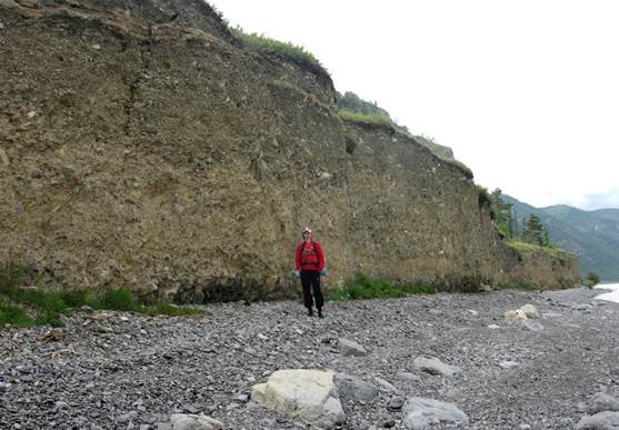
Fig. 46. Coastal cliff of the proluvial fan cone of the Mal valley. Kadilnaya, site 33a.
Рис. 46. Береговой обрыв пролювиального конуса выноса пади Мал. Кадильная, т.н. 33а.
The cliff of the terrace stretches along the shore of Lake Baikal over one kilometer. After 150–200 m, only the upper layer of coarse-block material remains in the cliff, and after one kilometer the terrace almost completely disappears, observed further only fragmentarily in the form of small shelves 10–20 m wide, abruptly ending towards Lake Baikal in the form of cliffs up to 10 m high. In rocky coastal outcrops, layers of carbonate rocks (0.5 to 5–10 m) are composed of thin-banded algal limestones, then fine-grained dark-gray massive weakly crystallized limestones and dolomites follow. Layers in site 56-09: 175Ð20.
References
Akulov N.I., Frolov A.O., Mashchuk I.M., Akulova V.V. Jurassic deposits of the southern part of the Irkutsk sedimentary basin Stratigraphy. Geological correlation. 2015. Vol. 23, No. 4. P. 40–63. DOI: 10.7868/S0869592X15040043
Around Baikal: Mini-Encyclopedia. Guide. S.N. Volkov. 4th ed., revised and supplemented by Irkutsk: RICO, 2001. 432 p.
Chechet B. Golets Trekhgolovyy // Priroda Baikala : sait. URL: https://nature.baikal.ru/phs/ph.shtml?id=84554&msid=325614 (accessed 1.08.2025)
Danilovich V.N. Metod poyasov v issledovanii fracturovati, svyazannogo s rupturnymi displacementami : Metod. rukovodstvo // Materialy po geologii i mineralnym Irkutskoy oblasti. Vyp. 2 (XXIX). Irkutsk : Irkutsk. polytechn. in-t, 1961. 47 p. Elektron. versiya pechat. publ. Rezhim dostupa: http://www.twirpx.org/file/485599/
Danilovich V.N. Tektonika yugo-vostochnogo okrainy pribaikalskoi jurassy [Tectonics of the south-eastern margin of the Baikal Jurassic]. Irkutsk, OGIZ Publ., 1941. 89 p.
Decisions of the All-Union Stratigraphic Conference on the Precambrian, Paleozoic and Quaternary System of Central Siberia. Novosibirsk, 1983.
Dolnik T.A., Nikolsky F.V. Geological map of the USSR at a scale of 1:200,000. Sir. East. Sayan. Sheet N-48-XXVII. Explained. Zap. / T.A. Dolnik, F.V. Nikolsky. Moscow, Gosgeoltekhizdat Publ., 1962. 89 p. Electron. Print version. Publish. Available at: https://www.geokniga.org/maps/4219
Geological map of the USSR. Scale 1 : 200 000, East Sayan series, sheet N-48-XXVII / T.A. Dolnik., Moskva : Gosgeoltekhizdat, 1962. 1 l. Elektron. versiya pechat. publ. Rezhim dostupa: https://www.geokniga.org/maps/4219
Geological map of the USSR. Scale 1 : 200 000. West Transbaikal series. M-48-IV / V.N. Kodachigov. Moscow, GUGK Publ., 1964. 1 l. Electron. Print version. Publish. Available at: https://www.geokniga.org/sites/geokniga/files/maps/m-48-iv-geologicheskaya-karta-sssr-seriya-zapadno-sabaykalskaya.jpg (May 20, 2025).
Kovalenko S.N., Dekabrev I.K., Yuriev A.A., Bogdanova I.A. Uchebnaya polevaya praktika po geokartirovaniyu na geologicheskom facultye Irkutskskogo universiteta [Educational field practice on geocarting at the geological faculty of Irkutsk University] // Geology and environment. 2023. Vol. 3, No. 2. P. 132–164. DOI 10.26516/2541-9641.2023.2.132
Mazukabzov A.M., Sizykh V.I. On the integument-scaly structure of the Western Baikal region. 1987. № 3. Pp. 87–90.
Mazukabzov A.M., Stanevich A.M., Gladchub D.P., Donskaya T.V. Dislocations in the late Eriphean complex of the Western Baikal region — reflection of the Caledonian collision events (south of the Siberian craton) // Geodynamic evolution of the lithosphere of the Central Asian mobile belt (from the ocean to the continent): Materials of the meeting. Vol. 4. Irkutsk: Institute of the Earth's Crust SB RAS, 2006. In 2 volumes. Vol. 1. P. 232–236.
Mongush A.R., Bokareva A.A., Podlinov A.N., Prokopchik V.V., Ritter V.S., Maksimov N.M., Kalinin V.S., Zaripov M.S., Dambaev S.A., Kovalenko S.N., Yasnygina T.A., Chuvashova I.S., Saranina E.V., Rasskazov S.V. Similarity and difference in the composition of the Middle Jurassic and Lower Pliocene deposits on the north-western coast of Lake Baikal: Assessment of the contribution of clastic material of the Primorsky Ridge to the alluvium of the middle part of the Pra-Manzurka Valley. 2023. Vol. 3, No. 4. P. 51–81. DOI 10.26516/2541-9641.2023.4.51.
Mongush A.R., Kovalenko S.N., Rasskazov S.V. Comparative analysis of trahidacite-rhyolite pebbles and sandy filler of the Middle Jurassic and Lower Pliocene deposits on the north-western shore of Lake Baikal. Irkutsk, April 16–19, 2024 Irkutsk: Izd. ISU, 2024. P. 94–95. DOI 10.26516/978-5-9624-2262-6.2024.1-217
Oliferovsky R.V., Sedunova E.A., Shametova I.B., Bashkirtsev A.V., Danilin D.A., Mongush A.R., Kovalenko S.N., Yasnygina T.A., Chuvashova I.S., Saranina E.V., Rasskazov S.V. Source of trakhidacite-rhyolite pebbles of the Middle Jurassic conglomerates on the north-western shore of Lake Baikal: comparison of pebbles with rocks of magmatic complexes of the Upper Paleozoic and Mesozoic Transbaikalia. 2022. T. 2, No. 4. P. 53–79. DOI 10.26516/2541-9641.2022.4.53
Shurygin B.L., Ankudimova L.A. O novykh svitakh Angarskoy mezhgornoy vpushina [On the new formations of the Angara intermountain depression]. 1981. No. 7. P. 50–55.
Sizykh V.I., Sizykh A.I. Sharyazhno-nadthrigovaya tektonika : ucheb. posobie. Irkutsk : Irkutsk. un-t, 2005. 196 p. Elektron. versiya pechat. publ. Rezhim dostupa: https://www.twirpx.org/file/585432/
Skoblo V.M., Lyamina N.A., Luzina I.V., Rudnev A.F. Kontinental'nyi verkhniy mesozoi Pribaikal'ya i Zabaykal'ya. Novosibirsk: Izd-vo SB RAN, 2001. 332 p. Elektron. versiya pechat. publ. Rezhim dostupa: https://www.geokniga.org/books/5646
State Geological Map of the Russian Federation. Scale 1 : 1 000 000 (third generation). Series Angara-Yeniseiskaya. Sheet N-48. Irkutsk. Explanatory note / T.F. Galimova, S.A. Permyakov, V.T. Bobrovsky, A.G. Pashkova, L.A. Bormotkina, S.A. Povarintseva, A.A. Matveychuk, M.M. Namolova, V.M. Sadriev. St. Petersburg: VSEGEI Card Factory. 2009. 574 p.
Stratigraphy of the USSR. Quaternary system. Half volume 2. Moscow, Nedra Publ., 1984. 554 p.
The Baikal Run (Scientific Excursion to Baikal) / O.T. Rusinek, G.F. Ufimtsev, V.A. Fialkov; Holes. Ed. by A.I. Kiselev; photogr. S.N. Podberezkin. Novosibirsk: Geo Academic Publishing House, 2009. 187 p.
The Legend of the Angara-Yenisei Series of the State Geological Map of the Russian Federation at a Scale of 1 : 1 000 000 (Third Edition) / compilation. M.L. Makhlaev, V.V. Komarov. Kn. 1-2. Krasnoyarsk, 2008.
Kovalenko Sergey Nikolaevich,
Candidate of Geological and Mineralogical Sciences,
664025, Irkutsk, Lenin st., 3,
Irkutsk State University, Faculty of Geology,
Associate Professor of the Dynamic Geology Chair,
tel.: (3952)20-16-39,
email: igpug@mail.ru
|
|
Article received: 21.07.2025; corrected: 16.08.2025; accepted: 19.09.2025.
FOR CITATION: Kovalenko S.N. Geology the western coast of Lake Baikal in the vicinity of the Bolshaya and Malaya Kadilnaya valleys // Geology and Environment. 2025. Vol. 5, No. 3. P. 54–93. DOI 10.26516/2541-9641.2025.3.54. EDN: ZLRYFT